IMAGES TAKEN NEAR TO
Aston, OSWESTRY, SY11 4JQ
Introduction
This page details the photographs taken nearby to SY11 4JQ by members of the Geograph project.
The Geograph project started in 2005 with the aim of publishing, organising and preserving representative images for every square kilometre of Great Britain, Ireland and the Isle of Man.

There are currently over 7.5m images from over14,400 individuals and you can help contribute to the project by visiting https://www.geograph.org.uk
Image Map
Images are licensed for reuse under creativecommons.org/licenses/by-sa/2.0
Notes
- Clicking on the map will re-center to the selected point.
- The higher the marker number, the further away the image location is from the centre of the postcode.
Image Listing (9 Images Found)
Images are licensed for reuse under creativecommons.org/licenses/by-sa/2.0
Image
Details
Distance
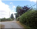
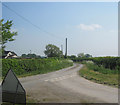
2
Gate at T junction at Fox Hall
Fox Hall to the left - road continues to the right
Image: © John Firth
Taken: 24 Jul 2013
0.05 miles
4
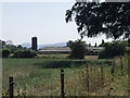
Fox Hall Farm dairy buildings
A comprehensive set of farm dairy buildings.
Image: © John Haynes
Taken: 17 Jul 2006
0.06 miles
6
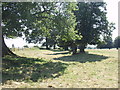
Old drive to Fox Hall
Fox Hall is part of the Aston Hall estate and at one time there was a drive connecting the two.
Image: © John Haynes
Taken: 17 Jul 2006
0.18 miles
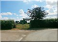
7
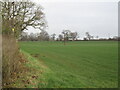
Field, Brook Lodge
At the junction between Chain Lane and Marsh Lane.
Image: © Richard Webb
Taken: 8 Feb 2022
0.22 miles
8
Foxhall cottages
The former cottages attached to Foxhall dairy farm.
Image: © John Haynes
Taken: 17 Jul 2006
0.22 miles
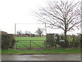
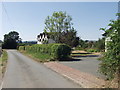
9
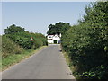
Brook Lodge
Typical of the houses and roads in this area. High, well maintained hedges including, in places large mature trees.
Image: © John Haynes
Taken: 17 Jul 2006
0.24 miles