IMAGES TAKEN NEAR TO
Weirbrook, West Felton, OSWESTRY, SY11 4ES
Introduction
This page details the photographs taken nearby to SY11 4ES by members of the Geograph project.
The Geograph project started in 2005 with the aim of publishing, organising and preserving representative images for every square kilometre of Great Britain, Ireland and the Isle of Man.

There are currently over 7.5m images from over14,400 individuals and you can help contribute to the project by visiting https://www.geograph.org.uk
Image Map
Images are licensed for reuse under creativecommons.org/licenses/by-sa/2.0
Notes
- Clicking on the map will re-center to the selected point.
- The higher the marker number, the further away the image location is from the centre of the postcode.
Image Listing (11 Images Found)
Images are licensed for reuse under creativecommons.org/licenses/by-sa/2.0
Image
Details
Distance
6
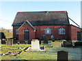
Weirbrook United Reformed Church
Viewed from the south-west.
Image: © Peter Wood
Taken: 4 Dec 2016
0.20 miles
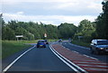
10
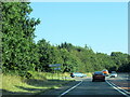
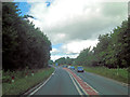
The A5 south at Holyhead Road junction for West Felton
Image: © Roy Hughes
Taken: 10 Aug 2022
0.22 miles