IMAGES TAKEN NEAR TO
Agnes Hunt Memorial Bungalows, OSWESTRY, SY11 3NB
Introduction
This page details the photographs taken nearby to Agnes Hunt Memorial Bungalows, SY11 3NB by members of the Geograph project.
The Geograph project started in 2005 with the aim of publishing, organising and preserving representative images for every square kilometre of Great Britain, Ireland and the Isle of Man.

There are currently over 7.5m images from over14,400 individuals and you can help contribute to the project by visiting https://www.geograph.org.uk
Image Map
Images are licensed for reuse under creativecommons.org/licenses/by-sa/2.0
Notes
- Clicking on the map will re-center to the selected point.
- The higher the marker number, the further away the image location is from the centre of the postcode.
Image Listing (14 Images Found)
Images are licensed for reuse under creativecommons.org/licenses/by-sa/2.0
Image
Details
Distance
1
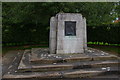
Gobowen: Agnes Gwendoline Hunt memorial
Dame Agnes Gwendoline Hunt (1867-1948) was a nurse who effectively founded the discipline of orthopaedic nursing. She founded a convalescent home for children at a family property near Shrewsbury, latterly in collaboration with the Liverpool surgeon Robert Jones; in 1919 this moved to the former military hospital site at Park Hall, Gobowen, as the Shropshire Orthopaedic Hospital. The hospital is still at the site, now known as The Robert Jones and Agnes Hunt Orthopaedic Hospital, whilst a school for the disabled children at the hospital developed into the adjacent Derwen College, a further education college for young adults with learning disabilities. This memorial stands at the entrance to Agnes Hunt Village, an area of bungalows owned by Derwen College.
More information about Dame Agnes Hunt can be found at https://en.wikipedia.org/wiki/Agnes_Hunt .
Image: © Christopher Hilton
Taken: 11 Sep 2020
0.03 miles
2
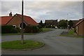
Gobowen: looking out of the entrance to Agnes Hunt Village
Image: © Christopher Hilton
Taken: 11 Sep 2020
0.07 miles
4
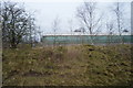
Railway line & cutting
Gobowen station can just be seen in the distance.
Image: © Row17
Taken: 7 Aug 2009
0.11 miles
5
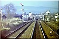
Gobowen South railway junction, 1983
A long-distance shot from a train heading towards Gobowen. The line from Oswestry approaches from the left. By 2020, all the sidings, point-work and the signal-box in this view had been removed, leaving just the two main tracks and the line from Oswestry.
Image: © Nigel Thompson
Taken: 22 Jan 1983
0.13 miles
6
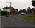
Whittington Road, Gobowen
Viewed from the corner of Old Whittington Road at the junction where the B5009
By Pass Road to the NW (left) becomes the B5009 Whittington Road ahead.
Image: © Jaggery
Taken: 15 Sep 2014
0.18 miles
7
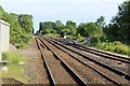
The disused lines to Oswestry
To the right are the original junction tracks to Oswestry part of which now forms the Cambrian Heritage Railway.
Image: © Richard Hoare
Taken: 10 Jun 2018
0.19 miles
8
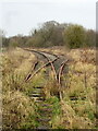
Passing place
On the disused single-track railway from Gobowen to Oswestry.
Image: © John H Darch
Taken: 7 Feb 2021
0.21 miles
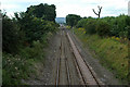
9

The line towards Shrewsbury at Gobowen
The line is approximately straight for the next 11000 metres. (For more detail see Image) Just beyond the foot crossing the line divides to the right which leads to Oswestry. It is now defunct although parts are being restored as part of the Cambrian Heritage Railway.
The line to the immediate right of the platform is again redundant.
Image: © Richard Hoare
Taken: 28 Oct 2022
0.22 miles
