IMAGES TAKEN NEAR TO
Glyn Morlas, OSWESTRY, SY11 3EF
Introduction
This page details the photographs taken nearby to Glyn Morlas, SY11 3EF by members of the Geograph project.
The Geograph project started in 2005 with the aim of publishing, organising and preserving representative images for every square kilometre of Great Britain, Ireland and the Isle of Man.

There are currently over 7.5m images from over14,400 individuals and you can help contribute to the project by visiting https://www.geograph.org.uk
Image Map (Loading...)


Getting Data...Please wait
Leaflet Map data © OpenStreetMap
Images are licensed for reuse under creativecommons.org/licenses/by-sa/2.0
Notes
- Clicking on the map will re-center to the selected point.
- The higher the marker number, the further away the image location is from the centre of the postcode.
Image Listing (8 Images Found)
Images are licensed for reuse under creativecommons.org/licenses/by-sa/2.0
Image
Details
Distance
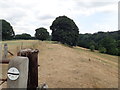
3
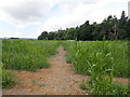
Maelor Way, through a field of maize
The Way links the Sandstone Trail, South Cheshire Way, Marches Way and Shropshire Way at Grindley Brook, to the Offa's Dyke Path National Trail at Chirk. It crosses farmland to Hanmer Mere and Overton, then follows woodland trails alongside the Rivers Dee and Ceiriog to Chirk. The Maelor Way uses public footpaths, bridleways, quiet lanes and canal towpath to pass from Grindley Brook through unspoiled undulating countryside to Bronygarth in the shadow of Chirk Castle.
Image: © Eirian Evans
Taken: 19 Jul 2018
0.14 miles
4
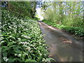
Wat's Dyke Way at Rhyn Lane
The trail runs from Llanymynech in Powys to Holywell in Flintshire following Wat's Dyke - a 40-mile earthwork.
Image: © Eirian Evans
Taken: 19 Jul 2018
0.15 miles
5
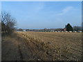
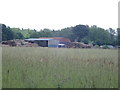
Pheasant rearing sheds in a field of maize stubble
This is a large game bird rearing enterprise.
Image: © John Haynes
Taken: 4 Mar 2013
0.16 miles
7
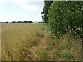
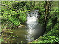
Maelor Way near Glanyrafon woods
The Way links the Sandstone Trail, South Cheshire Way, Marches Way and Shropshire Way at Grindley Brook, to the Offa's Dyke Path National Trail at Chirk. It crosses farmland to Hanmer Mere and Overton, then follows woodland trails alongside the Rivers Dee and Ceiriog to Chirk. The Maelor Way uses public footpaths, bridleways, quiet lanes and canal towpath to pass from Grindley Brook through unspoiled undulating countryside to Bronygarth in the shadow of Chirk Castle.
Image: © Eirian Evans
Taken: 19 Jul 2018
0.20 miles