IMAGES TAKEN NEAR TO
Balmoral Crescent, OSWESTRY, SY11 2XH
Introduction
This page details the photographs taken nearby to Balmoral Crescent, SY11 2XH by members of the Geograph project.
The Geograph project started in 2005 with the aim of publishing, organising and preserving representative images for every square kilometre of Great Britain, Ireland and the Isle of Man.

There are currently over 7.5m images from over14,400 individuals and you can help contribute to the project by visiting https://www.geograph.org.uk
Image Map (Loading...)


Getting Data...Please wait
Leaflet Map data © OpenStreetMap
Images are licensed for reuse under creativecommons.org/licenses/by-sa/2.0
Notes
- Clicking on the map will re-center to the selected point.
- The higher the marker number, the further away the image location is from the centre of the postcode.
Image Listing (17 Images Found)
Images are licensed for reuse under creativecommons.org/licenses/by-sa/2.0
Image
Details
Distance
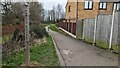
1
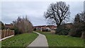
Public footpath leading from Community Centre eastwards
Image: © TCExplorer
Taken: 3 Mar 2023
0.02 miles
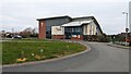
2

Eastern Oswestry Community Centre
Built in the 1990s.
Image: © TCExplorer
Taken: 3 Mar 2023
0.08 miles
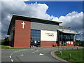
3
Cabin Lane Church
A modern church which was built in 2009. It also contains a café.
Image: © TCExplorer
Taken: 3 Mar 2023
0.09 miles
5
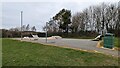
Skatepark near Eastern Oswestry Community Centre
Image: © TCExplorer
Taken: 3 Mar 2023
0.10 miles
6
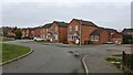
Small houses on Cabin Lane
A few small, I think 1990s, suburban houses off Cabin Lane.
Image: © TCExplorer
Taken: 3 Mar 2023
0.11 miles

8
Signage for the public footpath to Babbinswood
From here the footpath leaves the housing estate and crosses the A5
Image: © TCExplorer
Taken: 3 Mar 2023
0.13 miles
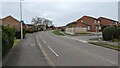
9
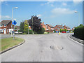
Junction of Cabin Lane and Balmoral Close
Image: © John Firth
Taken: 24 May 2010
0.14 miles