IMAGES TAKEN NEAR TO
Salop Road, OSWESTRY, SY11 2RQ
Introduction
This page details the photographs taken nearby to Salop Road, SY11 2RQ by members of the Geograph project.
The Geograph project started in 2005 with the aim of publishing, organising and preserving representative images for every square kilometre of Great Britain, Ireland and the Isle of Man.

There are currently over 7.5m images from over14,400 individuals and you can help contribute to the project by visiting https://www.geograph.org.uk
Image Map (Loading...)


Getting Data...Please wait
Leaflet Map data © OpenStreetMap
Images are licensed for reuse under creativecommons.org/licenses/by-sa/2.0
Notes
- Clicking on the map will re-center to the selected point.
- The higher the marker number, the further away the image location is from the centre of the postcode.
Image Listing (211 Images Found)
Images are licensed for reuse under creativecommons.org/licenses/by-sa/2.0
Image
Details
Distance
1
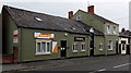
Oswestry Hypnotherapy
An Ellis Hypnosis Clinic is on the left, at 52A Salop Road. Hairspray hair salon is next door.
Image: © Jaggery
Taken: 15 Sep 2014
0.01 miles
2
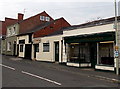
Days Upholsterers and the Little Sewing Shop in Oswestry
Two Salop Road shops.
Image: © Jaggery
Taken: 15 Sep 2014
0.02 miles
3
AJ's Garage, Oswestry
Viewed across a side road on the south side of Middleton Road.
Image: © Jaggery
Taken: 15 Sep 2014
0.02 miles
6
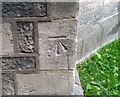
Ordnance Survey Cut Mark
This OS cut mark can be found on the west face of Holy Trinity Church. It marks a point 123.627m above mean sea level.
Image: © Adrian Dust
Taken: 22 Sep 2018
0.03 miles
7
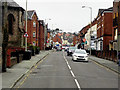
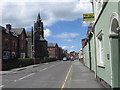
Middleton Road near the junction with Salop Road
Image: © Colin Pyle
Taken: 21 Nov 2009
0.03 miles
8
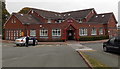
Plas Ffynnon Medical Centre, Oswestry
Set back from the south side of Middleton Road. Although Oswestry is in Shropshire, England,
about 5 miles (8km) east of the Welsh border, it has a mixed Welsh and English heritage.
There are many Welsh names in the town, as here.
Image: © Jaggery
Taken: 15 Sep 2014
0.03 miles
9
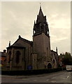
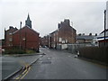
Holy Trinity Parish Church, Oswestry
The Roft Street and Salop Road corner of the church, viewed from Middleton Road.
The church is part of the Church of England Diocese of Lichfield.
Image: © Jaggery
Taken: 15 Sep 2014
0.03 miles
10
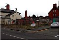
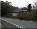
Fenced-off corner of Oswestry
The corner of Salop Road and Stewart Road viewed in September 2014. A Google Earth Street View taken in December 2009 shows this corner occupied by the premises of Jones & Hughes, monumental masons. The Black Lion pub http://www.geograph.org.uk/photo/4167954 is in the background on the left.
Image: © Jaggery
Taken: 15 Sep 2014
0.04 miles