IMAGES TAKEN NEAR TO
Salop Road, OSWESTRY, SY11 2RL
Introduction
This page details the photographs taken nearby to Salop Road, SY11 2RL by members of the Geograph project.
The Geograph project started in 2005 with the aim of publishing, organising and preserving representative images for every square kilometre of Great Britain, Ireland and the Isle of Man.

There are currently over 7.5m images from over14,400 individuals and you can help contribute to the project by visiting https://www.geograph.org.uk
Image Map (Loading...)


Getting Data...Please wait
Leaflet Map data © OpenStreetMap
Images are licensed for reuse under creativecommons.org/licenses/by-sa/2.0
Notes
- Clicking on the map will re-center to the selected point.
- The higher the marker number, the further away the image location is from the centre of the postcode.
Image Listing (41 Images Found)
Images are licensed for reuse under creativecommons.org/licenses/by-sa/2.0
Image
Details
Distance
2
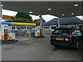
Petrol Station, Oswestry
On the B4579 Shrewsbury Road out of Oswestry.
Image: © Eirian Evans
Taken: 23 Sep 2007
0.04 miles
3

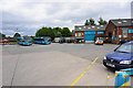
Homebase Store
Homebase store at Penda Retail park
Image: © John Firth
Taken: 28 Apr 2008
0.06 miles
4
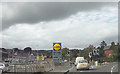
The new Lidl store Oswestry
The store used to be J.T.Hughes car dealer
Image: © John Firth
Taken: 12 Sep 2017
0.07 miles
6
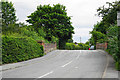
Shrewsbury Road crossing a defunct railway
The railway still has some rails and is crossed by the town's bypass.
Image: © Bill Boaden
Taken: 11 Jul 2015
0.10 miles

8
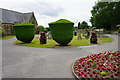
Entrance to Oswestry Cemetery
Are the shaped trees supposed to resemble urns?
Image: © Bill Boaden
Taken: 11 Jul 2015
0.11 miles
9
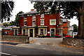
Park Issa Veterinary Hospital in Oswestry
Viewed across the B4579 Salop Road.
Image: © Jaggery
Taken: 15 Sep 2014
0.14 miles
10
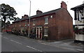
Former Trinity Terrace in Oswestry
Victorian row of houses with addresses now in Salop Road, built as Trinity Terrace in 1861,
as shown on the name tablet on the right edge of the row. The Black Lion pub http://www.geograph.org.uk/photo/4167954 is on the right.
Image: © Jaggery
Taken: 15 Sep 2014
0.14 miles