IMAGES TAKEN NEAR TO
Queens Road, OSWESTRY, SY11 2HY
Introduction
This page details the photographs taken nearby to Queens Road, SY11 2HY by members of the Geograph project.
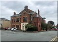
The Geograph project started in 2005 with the aim of publishing, organising and preserving representative images for every square kilometre of Great Britain, Ireland and the Isle of Man.

There are currently over 7.5m images from over14,400 individuals and you can help contribute to the project by visiting https://www.geograph.org.uk
Image Map (Loading...)


Getting Data...Please wait
Leaflet Map data © OpenStreetMap
Images are licensed for reuse under creativecommons.org/licenses/by-sa/2.0
Notes
- Clicking on the map will re-center to the selected point.
- The higher the marker number, the further away the image location is from the centre of the postcode.
Image Listing (93 Images Found)
Images are licensed for reuse under creativecommons.org/licenses/by-sa/2.0
Image
Details
Distance
1
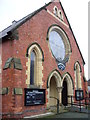
Horeb Chapel, Victoria Road, Oswestry
Front entrance to the Chapel which is Welsh Wesleyan Methodist.
Image: © Shirley Jones
Taken: 3 Mar 2010
0.08 miles
2
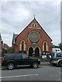
Horeb Methodist Church, Oswestry
The chapel was opened in 1878, to replace a chapel, called Bethesda in Penylan Lane which had been built in 1856, and before that they met in a room near the English Walls in Salop Road
Image: © Eirian Evans
Taken: 9 Oct 2021
0.09 miles
3
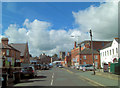
Victoria Road at the junction with Victoria Street
In the distance the Church of St. Oswald is a Grade II* listed building. Nothing in the foreground is of listed status.
Image: © Stuart Logan
Taken: 19 Sep 2013
0.11 miles
4
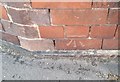
Ordnance Survey Cut Mark
This OS cut mark can be found on the Victoria Rooms. It marks a point 125.526m above mean sea level.
Image: © Adrian Dust
Taken: 22 Sep 2018
0.12 miles
5
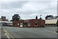
Victoria House
An imposing building at the junction of Victoria Road and Roft. Now an apartment block.
Image: © Eirian Evans
Taken: 9 Oct 2021
0.12 miles
7
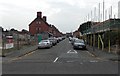
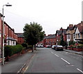
Stewart Road, Oswestry
Viewed across Salop Road looking along Stewart Road towards Ferrers Road.
Image: © Jaggery
Taken: 15 Sep 2014
0.14 miles
9
Ferrers Road, Oswestry
Viewed from the corner of Roft Street.
Image: © Jaggery
Taken: 15 Sep 2014
0.16 miles
10
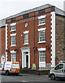
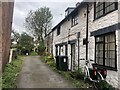
7 Lower Brook Street, Oswestry
A fine mid-C18th house, now used as offices, with painted quoins, keystones and, more unusually, a small round window. A show front, as can be seen by comparison with the facade round the corner. While several of its neighbours are listed, inexplicably this does not appear to be.
Image: © Stephen Richards
Taken: Unknown
0.16 miles