IMAGES TAKEN NEAR TO
Woodside, OSWESTRY, SY11 1EP
Introduction
This page details the photographs taken nearby to Woodside, SY11 1EP by members of the Geograph project.
The Geograph project started in 2005 with the aim of publishing, organising and preserving representative images for every square kilometre of Great Britain, Ireland and the Isle of Man.

There are currently over 7.5m images from over14,400 individuals and you can help contribute to the project by visiting https://www.geograph.org.uk
Image Map (Loading...)


Getting Data...Please wait
Leaflet Map data © OpenStreetMap
Images are licensed for reuse under creativecommons.org/licenses/by-sa/2.0
Notes
- Clicking on the map will re-center to the selected point.
- The higher the marker number, the further away the image location is from the centre of the postcode.
Image Listing (25 Images Found)
Images are licensed for reuse under creativecommons.org/licenses/by-sa/2.0
Image
Details
Distance
1
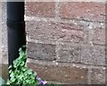
Ordnance Survey Cut Mark
This OS cut mark can be found on No63 Llwyn Road. It marks a point 127.815m above mean sea level.
Image: © Adrian Dust
Taken: 22 Sep 2018
0.10 miles
2
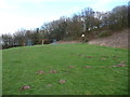
Part of a recreation ground near Oswestry
I've never played basketball on a slope - I would think that retrieving the basketball from downslope would become a bind after a while. The monkey bars are a good idea - local youngsters must have the grip strength of a male Mandrill, Macaque or Chimpanzee. Though the untrampled molehills argue that maybe this equipment doesn't see as much use as one would hope...
Image: © Jeremy Bolwell
Taken: 9 Mar 2012
0.11 miles
3
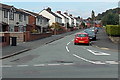
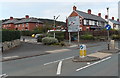
Cambrian Drive, Oswestry
Viewed from the Gobowen Road end.
Image: © Jaggery
Taken: 15 Sep 2014
0.12 miles
4
Llwyn Road, Oswestry
Viewed across Gobowen Road. Oswestry Convenience Store http://www.geograph.org.uk/photo/4173078 is on the right.
Image: © Jaggery
Taken: 15 Sep 2014
0.13 miles
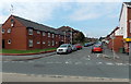
5
Coppice Drive, Oswestry
Viewed from Gobowen Road.
Image: © Jaggery
Taken: 15 Sep 2014
0.13 miles
6
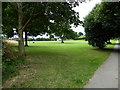
Gatacre Playing Field
A large, open aspect recreational field on the northern edge of Oswestry
Image: © Eirian Evans
Taken: 3 Aug 2016
0.15 miles
7
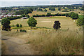
View over Gatacre Playing Fields
This is the view from the high ground to the east of Llwyn Road over the home of Cae Glas Cricket Club (not to be confused with the more senior Oswestry Cricket Club). The club has played here since 1976.
Image: © Stephen McKay
Taken: 14 Jul 2018
0.15 miles
8
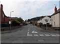
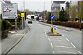
Junction ahead, Gobowen Road, Oswestry
The sign is between Gobowen Road on this side, and Western Drive.
It shows 14' 3" headroom under the bridge http://www.geograph.org.uk/photo/4173036 on the right turn route.
Image: © Jaggery
Taken: 15 Sep 2014
0.17 miles
10
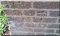
Ordnance Survey Cut Mark
This OS cut mark can be found on the north wall of the railway bridge. It marks a point 117.205m above mean sea level.
Image: © Adrian Dust
Taken: 22 Sep 2018
0.19 miles