IMAGES TAKEN NEAR TO
Gittin Street, OSWESTRY, SY11 1DT
Introduction
This page details the photographs taken nearby to Gittin Street, SY11 1DT by members of the Geograph project.
The Geograph project started in 2005 with the aim of publishing, organising and preserving representative images for every square kilometre of Great Britain, Ireland and the Isle of Man.

There are currently over 7.5m images from over14,400 individuals and you can help contribute to the project by visiting https://www.geograph.org.uk
Image Map (Loading...)


Getting Data...Please wait
Leaflet Map data © OpenStreetMap
Images are licensed for reuse under creativecommons.org/licenses/by-sa/2.0
Notes
- Clicking on the map will re-center to the selected point.
- The higher the marker number, the further away the image location is from the centre of the postcode.
Image Listing (36 Images Found)
Images are licensed for reuse under creativecommons.org/licenses/by-sa/2.0
Image
Details
Distance
1
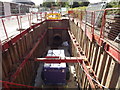
Vyrnwy Aqueduct Large Diameter Trunk Main
Image: © Mr M Evison
Taken: 11 Sep 2011
0.07 miles
2
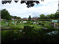
Gatacre Allotment site, Oswestry
Oswestry provides sixty allotments sites for its residents.
Image: © Eirian Evans
Taken: 3 Aug 2016
0.09 miles
3
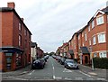
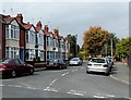
Gittin Street, Oswestry
Viewed across Beatrice Street looking towards Caer Road. Davis Meade's office http://www.geograph.org.uk/photo/4169919 is on the left.
Image: © Jaggery
Taken: 15 Sep 2014
0.13 miles
4
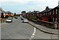
Caer Road, Oswestry
Looking NE from Lloyd Street and Swan Lane junction.
Image: © Jaggery
Taken: 15 Sep 2014
0.13 miles
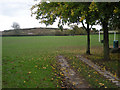
5
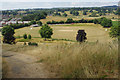
View over Gatacre Playing Fields
This is the view from the high ground to the east of Llwyn Road over the home of Cae Glas Cricket Club (not to be confused with the more senior Oswestry Cricket Club). The club has played here since 1976.
Image: © Stephen McKay
Taken: 14 Jul 2018
0.13 miles
6
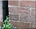
Ordnance Survey Cut Mark
This OS cut mark can be found on No63 Llwyn Road. It marks a point 127.815m above mean sea level.
Image: © Adrian Dust
Taken: 22 Sep 2018
0.13 miles
7
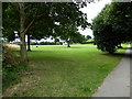
Gatacre Playing Field
A large, open aspect recreational field on the northern edge of Oswestry
Image: © Eirian Evans
Taken: 3 Aug 2016
0.16 miles
8
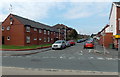
Llwyn Road, Oswestry
Viewed across Gobowen Road. Oswestry Convenience Store http://www.geograph.org.uk/photo/4173078 is on the right.
Image: © Jaggery
Taken: 15 Sep 2014
0.16 miles
9
Lloyd Street houses in Oswestry
Viewed from the corner of Caer Road looking NW.
Image: © Jaggery
Taken: 15 Sep 2014
0.16 miles
10
Playing Fields at Gatacre Ave
'Old Oswestry' hillfort is on the far side of these playing fields.
Image: © Row17
Taken: 29 Oct 2008
0.17 miles