IMAGES TAKEN NEAR TO
Nantmawr, OSWESTRY, SY10 9HH
Introduction
This page details the photographs taken nearby to SY10 9HH by members of the Geograph project.
The Geograph project started in 2005 with the aim of publishing, organising and preserving representative images for every square kilometre of Great Britain, Ireland and the Isle of Man.

There are currently over 7.5m images from over14,400 individuals and you can help contribute to the project by visiting https://www.geograph.org.uk
Image Map
Images are licensed for reuse under creativecommons.org/licenses/by-sa/2.0
Notes
- Clicking on the map will re-center to the selected point.
- The higher the marker number, the further away the image location is from the centre of the postcode.
Image Listing (24 Images Found)
Images are licensed for reuse under creativecommons.org/licenses/by-sa/2.0
Image
Details
Distance
1
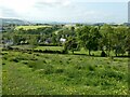
View on Offa's Dyke Path above Nantmawr
I took almost precisely the same shot back on 2010, see https://www.geograph.org.uk/photo/2059748 here. 13 years but I have paused in the same spot and not much has changed.
Image: © Jeremy Bolwell
Taken: 22 May 2023
0.08 miles
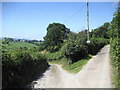
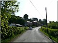
2
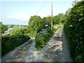
Lane junction above Nantmawr
Nice hillside lanes.
Image: © Jeremy Bolwell
Taken: 22 May 2023
0.08 miles
3
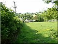
Offa's Dyke Path descends steeply down to Nantmawr village
The ODP runs down this grassy bank then crosses the next field diagonally to reach the village and road via a small green lane or hedged footpath. The old chapel building now appears to be a home. Though the graveyard is still there.
Image: © Jeremy Bolwell
Taken: 31 Aug 2010
0.09 miles
4
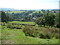
Looking down to part of Nantmawr from Offa's Dyke Path
What a joy to be walking this path on a May morning,
Image: © Jeremy Bolwell
Taken: 22 May 2023
0.10 miles
5
Lane Bifurcation near Nantmawr
Both are dead ends. The Offa's Dyke Trail elects to take the right hand fork to begin the ascent of Moelydd.
Image: © Chris Heaton
Taken: 26 Jul 2008
0.11 miles
6
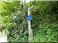
On part of Offa's Dyke Path between Nantmawr and Moelydd
A plastic ' blue plaque' in memory of one of the fallen of World War I; Private John Hugh Wooding who was killed age 23 and is listed on the Thiepval Memorial. He was in the Kings Shropshire Light Infantry. He lost his life before it had really begun.
We will remember them. Here's to you Mr Wooding.
Image: © Jeremy Bolwell
Taken: 22 May 2023
0.13 miles
9
Part of Nantmawr
Offa's Dyke Path follows this hill.
Image: © Jeremy Bolwell
Taken: 22 May 2023
0.15 miles
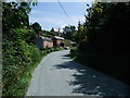
10
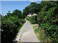
Lane towards Jones' Rough
The Offa's Dyke Path climbing towards the Nature Reserve woodland of Jones' Rough. The cottage is called 'Mount Zion'.
Image: © Tim Heaton
Taken: 26 Jul 2008
0.16 miles