IMAGES TAKEN NEAR TO
Whitridge Way, OSWESTRY, SY10 9FB
Introduction
This page details the photographs taken nearby to Whitridge Way, SY10 9FB by members of the Geograph project.
The Geograph project started in 2005 with the aim of publishing, organising and preserving representative images for every square kilometre of Great Britain, Ireland and the Isle of Man.

There are currently over 7.5m images from over14,400 individuals and you can help contribute to the project by visiting https://www.geograph.org.uk
Image Map
Images are licensed for reuse under creativecommons.org/licenses/by-sa/2.0
Notes
- Clicking on the map will re-center to the selected point.
- The higher the marker number, the further away the image location is from the centre of the postcode.
Image Listing (28 Images Found)
Images are licensed for reuse under creativecommons.org/licenses/by-sa/2.0
Image
Details
Distance
1
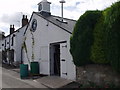
Offas Dyke Brewery, Trefonen
A micro brewery only established in May this year. At present supplying the Barley Mow Pub but it is planned to bottle some production soon.
http://www.offasdykebrewery.com/
Image: © John Haynes
Taken: 14 Sep 2007
0.05 miles
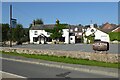
2

The Barley Mow pub
Traditional inn in Trefonen.
Image: © John Haynes
Taken: 14 Sep 2007
0.06 miles
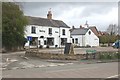
3
Barley Mow
Barley Mow inn and Offa's Dyke Brewery in the village of Trefonen
Image: © Philip Halling
Taken: 5 Sep 2023
0.06 miles
5
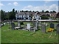
Graveyard, pub and brewery
The graveyard of All Saints looks over to the Barley Mow pub, which has its own micro-brewery (white building on right). One of the beers is aptly named 'The Grim Reaper'.
Image: © Tim Heaton
Taken: 26 Jul 2008
0.07 miles
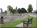
6
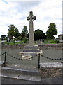
Trefonen War Memorial
At the south-west end of the churchyard.
Image: © John H Darch
Taken: 25 Sep 2019
0.08 miles
7
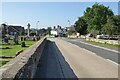
Treflech Road
Oswestry Road in Trefonen.
Image: © Philip Halling
Taken: 5 Sep 2023
0.08 miles
8
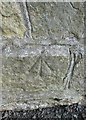
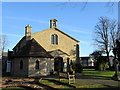
Ordnance Survey Pivot
This OS pivot can be found on the west face of All Saints Church. It marks a point 182.414m above mean sea level.
Image: © Adrian Dust
Taken: 12 May 2016
0.08 miles
9
War Memorial and graveyard to All Saints Church, Trefonen
Some recent changes in road layouts has made it easier to view the memorial.
Image: © John Haynes
Taken: 14 Sep 2007
0.08 miles