IMAGES TAKEN NEAR TO
Sweeney, OSWESTRY, SY10 9EX
Introduction
This page details the photographs taken nearby to SY10 9EX by members of the Geograph project.
The Geograph project started in 2005 with the aim of publishing, organising and preserving representative images for every square kilometre of Great Britain, Ireland and the Isle of Man.

There are currently over 7.5m images from over14,400 individuals and you can help contribute to the project by visiting https://www.geograph.org.uk
Image Map
Images are licensed for reuse under creativecommons.org/licenses/by-sa/2.0
Notes
- Clicking on the map will re-center to the selected point.
- The higher the marker number, the further away the image location is from the centre of the postcode.
Image Listing (3 Images Found)
Images are licensed for reuse under creativecommons.org/licenses/by-sa/2.0
Image
Details
Distance
3
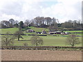
Upper Sweeney Farm
Set of farm buildings typical of a livestock farm in this area. The field in the immediate foreground is swedes that has been grazed by sheep "on the brick".
Image: © John Haynes
Taken: 9 Apr 2006
0.24 miles