IMAGES TAKEN NEAR TO
Nantmawr, OSWESTRY, SY10 9EG
Introduction
This page details the photographs taken nearby to SY10 9EG by members of the Geograph project.
The Geograph project started in 2005 with the aim of publishing, organising and preserving representative images for every square kilometre of Great Britain, Ireland and the Isle of Man.

There are currently over 7.5m images from over14,400 individuals and you can help contribute to the project by visiting https://www.geograph.org.uk
Image Map
Images are licensed for reuse under creativecommons.org/licenses/by-sa/2.0
Notes
- Clicking on the map will re-center to the selected point.
- The higher the marker number, the further away the image location is from the centre of the postcode.
Image Listing (6 Images Found)
Images are licensed for reuse under creativecommons.org/licenses/by-sa/2.0
Image
Details
Distance
1
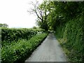
Lane approaching Ty-newydd farm
An access lane for a few rural farms or properties.
Image: © Jeremy Bolwell
Taken: 22 May 2023
0.04 miles
2
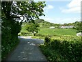
Lane junction
A veritable Piccadilly Circus for these parts.
Image: © Jeremy Bolwell
Taken: 22 May 2023
0.11 miles

5
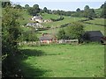
Cottage and outbuildings
The cottage seems much smaller than the associated outbuildings.
Image: © Philip Ingram
Taken: 11 Sep 2007
0.22 miles
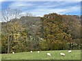
6
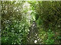
Little narrow sunken way
Used by motorbike scramblers and not many other people.
Image: © Jeremy Bolwell
Taken: 22 May 2023
0.23 miles