IMAGES TAKEN NEAR TO
Trefonen, OSWESTRY, SY10 9EB
Introduction
This page details the photographs taken nearby to SY10 9EB by members of the Geograph project.
The Geograph project started in 2005 with the aim of publishing, organising and preserving representative images for every square kilometre of Great Britain, Ireland and the Isle of Man.

There are currently over 7.5m images from over14,400 individuals and you can help contribute to the project by visiting https://www.geograph.org.uk
Image Map
Images are licensed for reuse under creativecommons.org/licenses/by-sa/2.0
Notes
- Clicking on the map will re-center to the selected point.
- The higher the marker number, the further away the image location is from the centre of the postcode.
Image Listing (4 Images Found)
Images are licensed for reuse under creativecommons.org/licenses/by-sa/2.0
Image
Details
Distance
1
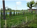
Fishing lake beside Offa's Dyke Path
Double fencing and conifer hedge just to keep us out.
Image: © Jeremy Bolwell
Taken: 22 May 2023
0.18 miles
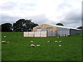
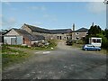
4
Ty-Canol
Farming operation passed on the Offa's Dyke Path between Nantmawr and Trefonen.
Image: © Chris Heaton
Taken: 26 Jul 2008
0.23 miles