IMAGES TAKEN NEAR TO
Croesau Bach, OSWESTRY, SY10 9BQ
Introduction
This page details the photographs taken nearby to SY10 9BQ by members of the Geograph project.
The Geograph project started in 2005 with the aim of publishing, organising and preserving representative images for every square kilometre of Great Britain, Ireland and the Isle of Man.

There are currently over 7.5m images from over14,400 individuals and you can help contribute to the project by visiting https://www.geograph.org.uk
Image Map
Images are licensed for reuse under creativecommons.org/licenses/by-sa/2.0
Notes
- Clicking on the map will re-center to the selected point.
- The higher the marker number, the further away the image location is from the centre of the postcode.
Image Listing (9 Images Found)
Images are licensed for reuse under creativecommons.org/licenses/by-sa/2.0
Image
Details
Distance

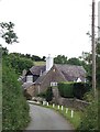
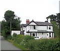
3
House at Croesau Bach
The name and house style may be Welsh but this house is in Shropshire.
Image: © Philip Ingram
Taken: 11 Sep 2007
0.06 miles

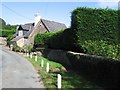
5
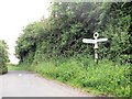
Road junction at Croesau Bach
Nerar Ty Carreg
Image: © John Firth
Taken: 4 Jul 2013
0.09 miles
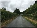

9
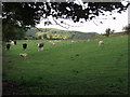
Mixed grazing near Croesau Bach
Sheep and beef stots mix graze the last of the summer grass.
Image: © John Haynes
Taken: 14 Sep 2007
0.15 miles