IMAGES TAKEN NEAR TO
Llansilin, OSWESTRY, SY10 9BL
Introduction
This page details the photographs taken nearby to SY10 9BL by members of the Geograph project.
The Geograph project started in 2005 with the aim of publishing, organising and preserving representative images for every square kilometre of Great Britain, Ireland and the Isle of Man.

There are currently over 7.5m images from over14,400 individuals and you can help contribute to the project by visiting https://www.geograph.org.uk
Image Map
Images are licensed for reuse under creativecommons.org/licenses/by-sa/2.0
Notes
- Clicking on the map will re-center to the selected point.
- The higher the marker number, the further away the image location is from the centre of the postcode.
Image Listing (7 Images Found)
Images are licensed for reuse under creativecommons.org/licenses/by-sa/2.0
Image
Details
Distance

2
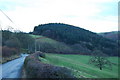
Looking South West to Graig-wen Wood
A single species plantation of Sitka Spruce.
Image: © John Haynes
Taken: 6 Jan 2008
0.09 miles
4
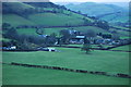
Large farm right on the Wales / England border
A large livestock farm with a range of traditional and modern buildings.
Image: © John Haynes
Taken: 6 Jan 2008
0.11 miles
5
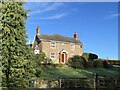
Stone and brick farmhouse
Most of the walls of the house are in undressed stone of random sizes but the corners, windows and doors are in brick.
Image: © Philip Ingram
Taken: 11 Sep 2007
0.13 miles
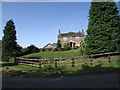
7
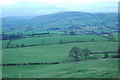
Extensive sheep grazings
Large fields here looking across toward Llansilin. In the right hand side of the second field down you can see the pattern of land drainage that has been put in.
Image: © John Haynes
Taken: 6 Jan 2008
0.23 miles