IMAGES TAKEN NEAR TO
Craigllwyn, OSWESTRY, SY10 9BH
Introduction
This page details the photographs taken nearby to SY10 9BH by members of the Geograph project.
The Geograph project started in 2005 with the aim of publishing, organising and preserving representative images for every square kilometre of Great Britain, Ireland and the Isle of Man.

There are currently over 7.5m images from over14,400 individuals and you can help contribute to the project by visiting https://www.geograph.org.uk
Image Map
Images are licensed for reuse under creativecommons.org/licenses/by-sa/2.0
Notes
- Clicking on the map will re-center to the selected point.
- The higher the marker number, the further away the image location is from the centre of the postcode.
Image Listing (5 Images Found)
Images are licensed for reuse under creativecommons.org/licenses/by-sa/2.0
Image
Details
Distance
3
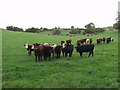
Beef stots grazing at Craig-llwyn
Excellent grazing along this area of lower ground.
Image: © John Haynes
Taken: 14 Sep 2007
0.08 miles
4
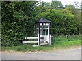
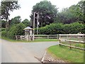
Edwardian shelter
Every rural child would love to have this great shelter at the end of their farm track whilst waiting to be bussed to school. Probably not its original use but looks the part now.
Image: © John Haynes
Taken: 14 Sep 2007
0.13 miles
5
Entrance to track to Panthir
Old Edwardian bus shelter at start of track.
Image: © John Firth
Taken: 4 Jul 2013
0.15 miles