IMAGES TAKEN NEAR TO
Croesau Bach, OSWESTRY, SY10 9BE
Introduction
This page details the photographs taken nearby to SY10 9BE by members of the Geograph project.
The Geograph project started in 2005 with the aim of publishing, organising and preserving representative images for every square kilometre of Great Britain, Ireland and the Isle of Man.

There are currently over 7.5m images from over14,400 individuals and you can help contribute to the project by visiting https://www.geograph.org.uk
Image Map
Images are licensed for reuse under creativecommons.org/licenses/by-sa/2.0
Notes
- Clicking on the map will re-center to the selected point.
- The higher the marker number, the further away the image location is from the centre of the postcode.
Image Listing (4 Images Found)
Images are licensed for reuse under creativecommons.org/licenses/by-sa/2.0
Image
Details
Distance
1
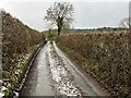
Track to Pentregaer Uchaf
There is a large barn in the field. Taken from cattle grid
Image: © John Firth
Taken: 4 Jul 2013
0.07 miles
2
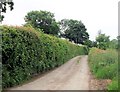
Lane to Pentregaer Issa
Taken from junction of lane to Pentregaer Uchaf
Image: © John Firth
Taken: 4 Jul 2013
0.07 miles
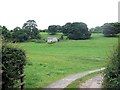
3
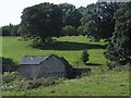
Field barn below Llyn Rhuddwyn
This is a very large stone barn. Unexpectedly, there is a lake in the wood above it.
Image: © Philip Ingram
Taken: 11 Sep 2007
0.08 miles