IMAGES TAKEN NEAR TO
Gronwen, Morda, OSWESTRY, SY10 9AR
Introduction
This page details the photographs taken nearby to SY10 9AR by members of the Geograph project.
The Geograph project started in 2005 with the aim of publishing, organising and preserving representative images for every square kilometre of Great Britain, Ireland and the Isle of Man.

There are currently over 7.5m images from over14,400 individuals and you can help contribute to the project by visiting https://www.geograph.org.uk
Image Map
Images are licensed for reuse under creativecommons.org/licenses/by-sa/2.0
Notes
- Clicking on the map will re-center to the selected point.
- The higher the marker number, the further away the image location is from the centre of the postcode.
Image Listing (3 Images Found)
Images are licensed for reuse under creativecommons.org/licenses/by-sa/2.0
Image
Details
Distance
1

Buildings and houses at Gronwen
A mixed group of buildings including a partially built kit house.
Image: © John Haynes
Taken: 14 Sep 2007
0.04 miles
2

Gronwen Farm
Small mixed farm with mainly livestock buildings.
Image: © John Haynes
Taken: 14 Sep 2007
0.05 miles
3
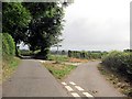
Road junction near Gronwen
Road to right leads to Gronwen
Image: © John Firth
Taken: 4 Jul 2013
0.20 miles