IMAGES TAKEN NEAR TO
Melverley, OSWESTRY, SY10 8PN
Introduction
This page details the photographs taken nearby to SY10 8PN by members of the Geograph project.
The Geograph project started in 2005 with the aim of publishing, organising and preserving representative images for every square kilometre of Great Britain, Ireland and the Isle of Man.

There are currently over 7.5m images from over14,400 individuals and you can help contribute to the project by visiting https://www.geograph.org.uk
Image Map
Images are licensed for reuse under creativecommons.org/licenses/by-sa/2.0
Notes
- Clicking on the map will re-center to the selected point.
- The higher the marker number, the further away the image location is from the centre of the postcode.
Image Listing (4 Images Found)
Images are licensed for reuse under creativecommons.org/licenses/by-sa/2.0
Image
Details
Distance
1
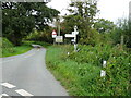
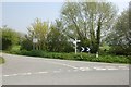
Road junction at Ponthen , east of Melverley
Plenty of signage at this minor road junction - I’m heading left to Melverley on The Shropshire Way. The road also carries The Severn Way footpath for a short distance here. On the right of the photo you can just see a normal footpath sign pointing into the fields. I’m glad I was not going that way - impassable with head high nettles and brambles!
Image: © Andrew Shannon
Taken: 30 Aug 2023
0.17 miles
3
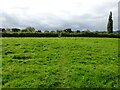
Footpath crossing field near Melverley
The grass was long and wet in this field but the Shropshire Way footpath was just visible. I’d just passed a horse and a pony, who both looked suspiciously at me. The grass here will keep them happy for a good time.
Image: © Andrew Shannon
Taken: 30 Aug 2023
0.20 miles
4
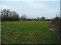
Severn pastures
Grassland on the Severn flood plain near Ponthen.
Image: © Jonathan Billinger
Taken: 3 Jan 2008
0.20 miles