IMAGES TAKEN NEAR TO
Melverley, OSWESTRY, SY10 8PF
Introduction
This page details the photographs taken nearby to SY10 8PF by members of the Geograph project.
The Geograph project started in 2005 with the aim of publishing, organising and preserving representative images for every square kilometre of Great Britain, Ireland and the Isle of Man.

There are currently over 7.5m images from over14,400 individuals and you can help contribute to the project by visiting https://www.geograph.org.uk
Image Map
Images are licensed for reuse under creativecommons.org/licenses/by-sa/2.0
Notes
- Clicking on the map will re-center to the selected point.
- The higher the marker number, the further away the image location is from the centre of the postcode.
Image Listing (4 Images Found)
Images are licensed for reuse under creativecommons.org/licenses/by-sa/2.0
Image
Details
Distance

2
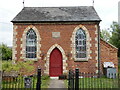
Primitive Methodist Chapel in Melverley Green
The inscription gives the date of 1865 - an active building time for this religious movement.
Image: © Andrew Shannon
Taken: 6 Jun 2022
0.14 miles
3

Road junction by Melverley Methodist church.
Image: © John Firth
Taken: 14 May 2008
0.15 miles
4

Old Direction Sign - Signpost north of Melverley Green
Annulus finial - 3 arms; Shropshire CC modern halo by the UC road, in parish of Melverley (Oswestry District), T junction between Melverley Green and Crosslanes, on verge, against hedge, beside gate.
Surveyed
Milestone Society National ID: SA_SJ3218.
Image: © Milestone Society
Taken: Unknown
0.18 miles