IMAGES TAKEN NEAR TO
Llanyblodwel, OSWESTRY, SY10 8NE
Introduction
This page details the photographs taken nearby to SY10 8NE by members of the Geograph project.
The Geograph project started in 2005 with the aim of publishing, organising and preserving representative images for every square kilometre of Great Britain, Ireland and the Isle of Man.

There are currently over 7.5m images from over14,400 individuals and you can help contribute to the project by visiting https://www.geograph.org.uk
Image Map
Images are licensed for reuse under creativecommons.org/licenses/by-sa/2.0
Notes
- Clicking on the map will re-center to the selected point.
- The higher the marker number, the further away the image location is from the centre of the postcode.
Image Listing (5 Images Found)
Images are licensed for reuse under creativecommons.org/licenses/by-sa/2.0
Image
Details
Distance
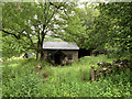
1
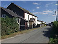
Farm just east of Prospect farm water works
Image: © John Firth
Taken: 23 Feb 2010
0.02 miles
3
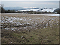
Snow and stubble looking towards Llanyblodwell
Image: © John Firth
Taken: 23 Feb 2010
0.23 miles
4
Wesleyan Chapel at Nantmawr
Great little chapel with magnificent views front and back. First established in 1840, the present building dates from 1863.
Image: © John Haynes
Taken: 7 Sep 2007
0.24 miles