IMAGES TAKEN NEAR TO
Llanyblodwel, OSWESTRY, SY10 8ND
Introduction
This page details the photographs taken nearby to SY10 8ND by members of the Geograph project.
The Geograph project started in 2005 with the aim of publishing, organising and preserving representative images for every square kilometre of Great Britain, Ireland and the Isle of Man.

There are currently over 7.5m images from over14,400 individuals and you can help contribute to the project by visiting https://www.geograph.org.uk
Image Map
Images are licensed for reuse under creativecommons.org/licenses/by-sa/2.0
Notes
- Clicking on the map will re-center to the selected point.
- The higher the marker number, the further away the image location is from the centre of the postcode.
Image Listing (3 Images Found)
Images are licensed for reuse under creativecommons.org/licenses/by-sa/2.0
Image
Details
Distance
1
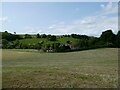
Rural property in the Tanat valley near Llanyblodwel
Nice place, substantial with eye-catching chimneys.
Image: © Jeremy Bolwell
Taken: 22 May 2023
0.09 miles
2
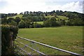
Hillside near Llanyblodwel
Afon Tanat runs next to the first line of trees.
Image: © Peter Craine
Taken: 10 Sep 2007
0.14 miles
3
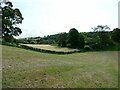
Walking in a field by the church in Llanyblodwel
Interesting landscape near the river.
Image: © Jeremy Bolwell
Taken: 22 May 2023
0.17 miles