IMAGES TAKEN NEAR TO
Porth-y-Waen, OSWESTRY, SY10 8LX
Introduction
This page details the photographs taken nearby to SY10 8LX by members of the Geograph project.
The Geograph project started in 2005 with the aim of publishing, organising and preserving representative images for every square kilometre of Great Britain, Ireland and the Isle of Man.

There are currently over 7.5m images from over14,400 individuals and you can help contribute to the project by visiting https://www.geograph.org.uk
Image Map
Images are licensed for reuse under creativecommons.org/licenses/by-sa/2.0
Notes
- Clicking on the map will re-center to the selected point.
- The higher the marker number, the further away the image location is from the centre of the postcode.
Image Listing (10 Images Found)
Images are licensed for reuse under creativecommons.org/licenses/by-sa/2.0
Image
Details
Distance
2
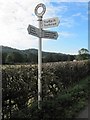
Old Direction Sign - Signpost by the A495, east of Porth-y-Waen
Annulus finial - 3 arms; Shropshire CC modern halo by the A495, by the junction with Coopers Lane, in parish of Oswestry Rural (Oswestry District), East of Porth-y-Waen.
Surveyed
Milestone Society National ID: SA_SJ2623
Image: © Milestone Society
Taken: Unknown
0.12 miles
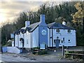
4
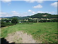
View towards Porth-y-waen
The village sits at the foot of a hill (right horizon) whose centre has been cut out to form Whitehaven Quarry.
Image: © Tim Heaton
Taken: 26 Jul 2008
0.13 miles
5
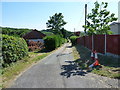
Village track between Cefn Lane and Porth Y Waen
Image: © Richard Law
Taken: 2 Jul 2018
0.14 miles

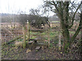
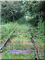
8
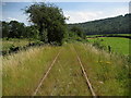
Disused Railway south of Porth-y-waen
This is part of the old Tanat Valley Line that ran from Oswestry to Llangynog for the transportation of minerals. It was completed in 1904, and continued in operation until 1960. It is unusual to find the metal rails are still in place after all this time.
Image: © Chris Heaton
Taken: 26 Jul 2008
0.23 miles
9
Disused railway, Porth-y-Waen
Seen from the crossing point of Offa's Dyke Path.
Image: © John Allan
Taken: 26 Jun 2019
0.24 miles