IMAGES TAKEN NEAR TO
Penygarreg Lane, OSWESTRY, SY10 8JS
Introduction
This page details the photographs taken nearby to Penygarreg Lane, SY10 8JS by members of the Geograph project.
The Geograph project started in 2005 with the aim of publishing, organising and preserving representative images for every square kilometre of Great Britain, Ireland and the Isle of Man.

There are currently over 7.5m images from over14,400 individuals and you can help contribute to the project by visiting https://www.geograph.org.uk
Image Map
Images are licensed for reuse under creativecommons.org/licenses/by-sa/2.0
Notes
- Clicking on the map will re-center to the selected point.
- The higher the marker number, the further away the image location is from the centre of the postcode.
Image Listing (13 Images Found)
Images are licensed for reuse under creativecommons.org/licenses/by-sa/2.0
Image
Details
Distance
1
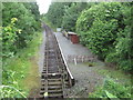
Pen-y-Garreg Lane Halt railway station, Shropshire
Opened in 2011 by the Cambrian Heritage Railway Society as the end of its line from Llynclys South. The line rebuilds part of the Oswestry and Newtown Railway of 1864, later part of the Cambrian Railways main line.
View north towards Llynclys South and Oswestry.
Image: © Nigel Thompson
Taken: 6 Jun 2017
0.10 miles
2
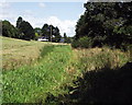
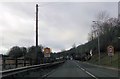
Course of Montgomery Canal at Pant
This section of the Montgomery canal is dry and the fences and boundaries are gone. The canal has tended to blend into the fields, but can clearly be seen. Redevelopment of this section is dependent on road developments.
Image: © John Haynes
Taken: 20 Aug 2000
0.11 miles
4

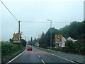
Sign of The Times
It's not pretty but this records Friday 20th February, in Pant. - http://www.countytimes.co.uk/news/Tears-as-up-to-80.4997740.jp
Image: © Rod Trevaskus
Taken: 20 Feb 2009
0.16 miles
5
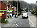
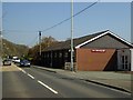
Shops at Pant
Passing the Co-op and Post Office at Pant, a village in Shropshire which lies near the border with Wales. The name "Pant" means "a hollow" in Welsh.
Image: © David Dixon
Taken: 15 Apr 2016
0.16 miles
7
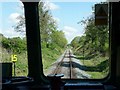
The view back up the line
Taken from the stationary train at the southern end of the line, as the driver changed ends.
Image: © Christine Johnstone
Taken: 9 May 2010
0.19 miles
8
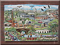
Armistice 100 artwork at Pant Memorial Hall
Commissioned to mark the centenary of the Armistice - very appropriate for a village hall built as a World War 1 memorial. The artwork was designed with input from the community and funded entirely by grants. The associated car park improvements and explanatory plaque were also provided by generous donors.
The artwork commemorates the armistice and also celebrates the beautiful area in which we live. More information on the hall website, www.pantmemorialhall.org.uk
Image: © Helen
Taken: 27 May 2019
0.20 miles
9
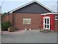
Pant Memorial Hall with new artwork, summer 2019
A view of the entrance to Pant Memorial Hall, showing the Armistice100 commemorative artwork and the associated car park improvements, plus new plantings.
The artwork is placed so that anyone can stop and look, whether or not the hall is open. The gravel and planters are placed to ensure that no-one can park in front of the artwork. This both protects the ceramic and ensures that the fire exit route from the hall is kept clear.
Read more about the artwork project on the hall website, www.pantmemorialhall.org.uk
Image: © Helen
Taken: 2 Jun 2019
0.20 miles