IMAGES TAKEN NEAR TO
Maesbury, OSWESTRY, SY10 8HD
Introduction
This page details the photographs taken nearby to SY10 8HD by members of the Geograph project.
The Geograph project started in 2005 with the aim of publishing, organising and preserving representative images for every square kilometre of Great Britain, Ireland and the Isle of Man.

There are currently over 7.5m images from over14,400 individuals and you can help contribute to the project by visiting https://www.geograph.org.uk
Image Map
Images are licensed for reuse under creativecommons.org/licenses/by-sa/2.0
Notes
- Clicking on the map will re-center to the selected point.
- The higher the marker number, the further away the image location is from the centre of the postcode.
Image Listing (8 Images Found)
Images are licensed for reuse under creativecommons.org/licenses/by-sa/2.0
Image
Details
Distance
2
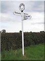
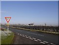
Direction Sign - Signpost by Maesbury Road, Maesbury
Annulus finial - 3 arms; Shropshire CC modern halo by the UC road, in parish of Oswestry Rural (Oswestry District), Maesbury.
Surveyed
Milestone Society National ID: SA_SJ3026
Image: © Milestone Society
Taken: Unknown
0.08 miles
3

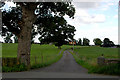
Frosted fields, Maesbury
Winter anticyclone - fog had just lifted leaving everything frosted.
Image: © Richard Webb
Taken: 29 Dec 2016
0.08 miles


6
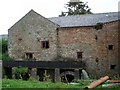
Ball Mill
Watermill with two waterwheels. The building shows signs of many phases of development and a wide variety of materials. The machinery survives largely intact.
Image: © Gareth Hughes
Taken: 8 Sep 2007
0.22 miles
7
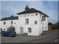
The Original Ball Inn
At Ball on the Maesbury Road from Oswestry
Image: © John Firth
Taken: 27 Apr 2010
0.23 miles