IMAGES TAKEN NEAR TO
Kynaston, Kinnerley, OSWESTRY, SY10 8EF
Introduction
This page details the photographs taken nearby to SY10 8EF by members of the Geograph project.
The Geograph project started in 2005 with the aim of publishing, organising and preserving representative images for every square kilometre of Great Britain, Ireland and the Isle of Man.

There are currently over 7.5m images from over14,400 individuals and you can help contribute to the project by visiting https://www.geograph.org.uk
Image Map
Images are licensed for reuse under creativecommons.org/licenses/by-sa/2.0
Notes
- Clicking on the map will re-center to the selected point.
- The higher the marker number, the further away the image location is from the centre of the postcode.
Image Listing (4 Images Found)
Images are licensed for reuse under creativecommons.org/licenses/by-sa/2.0
Image
Details
Distance
3
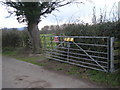
Not OTT security
The green sign on the gate states 'Please close this gate'. The 'MOD Keep Out' sign doesn't help either as this barb-wired gate is left wide open.
Image: © Row17
Taken: 9 Apr 2008
0.16 miles