IMAGES TAKEN NEAR TO
Newbridge, OSWESTRY, SY10 8BA
Introduction
This page details the photographs taken nearby to SY10 8BA by members of the Geograph project.
The Geograph project started in 2005 with the aim of publishing, organising and preserving representative images for every square kilometre of Great Britain, Ireland and the Isle of Man.

There are currently over 7.5m images from over14,400 individuals and you can help contribute to the project by visiting https://www.geograph.org.uk
Image Map
Images are licensed for reuse under creativecommons.org/licenses/by-sa/2.0
Notes
- Clicking on the map will re-center to the selected point.
- The higher the marker number, the further away the image location is from the centre of the postcode.
Image Listing (5 Images Found)
Images are licensed for reuse under creativecommons.org/licenses/by-sa/2.0
Image
Details
Distance
1
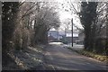
Maesbury
Frosted trees by Maesbury Hall.
Image: © Richard Webb
Taken: 29 Dec 2016
0.14 miles
2
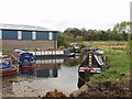
Benefits of re-opening a canal
When the Aston to Gronwen Wharf section of the Montgomery Canal opened in 2004 Maesbury Marine Services was a fledgling company at Maesbury Mill, it is now a thriving marine business with lots of boats either moored or being maintained.
http://www.maesburymarineservices.co.uk/
Image: © John Haynes
Taken: 15 Oct 2007
0.17 miles
3
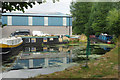
Peate's Mill Arm, Maesbury
There is a short arm off the Montgomery Canal which once served a grain mill, now a small industrial estate; it is home to a handful of narrowboats. Until the mid-1930s boats plied between here and Ellesmere Port on a regular basis but the traffic ceased when a breach closed the canal until restoration many decades later.
Image: © Stephen McKay
Taken: 15 Jul 2018
0.19 miles
4
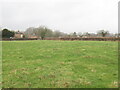
Field, Maesbury
A field, surrounded by roads.
Image: © Richard Webb
Taken: 8 Feb 2022
0.22 miles
5
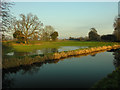
View from towpath of Shropshire Union Canal Montgomeryshire Branch of flooded field
Image: © David Hancock
Taken: 21 Dec 2006
0.22 miles