IMAGES TAKEN NEAR TO
Rhydycroesau, OSWESTRY, SY10 7JB
Introduction
This page details the photographs taken nearby to SY10 7JB by members of the Geograph project.
The Geograph project started in 2005 with the aim of publishing, organising and preserving representative images for every square kilometre of Great Britain, Ireland and the Isle of Man.

There are currently over 7.5m images from over14,400 individuals and you can help contribute to the project by visiting https://www.geograph.org.uk
Image Map
Images are licensed for reuse under creativecommons.org/licenses/by-sa/2.0
Notes
- Clicking on the map will re-center to the selected point.
- The higher the marker number, the further away the image location is from the centre of the postcode.
Image Listing (4 Images Found)
Images are licensed for reuse under creativecommons.org/licenses/by-sa/2.0
Image
Details
Distance
1
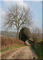
Track on Gallt-y-wrach
The lane from Rhydycroesau becomes a track which climbs through sheep pasture on the Gallt-y-wrach hillside. Baker's Hill is visible in the distance
Image: © Espresso Addict
Taken: 31 Mar 2007
0.17 miles
2
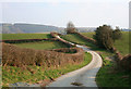
Lane from Rhydycroesau
This steep single-track lane winds its way from the village of Rhydycroesau; around 150m west of here it becomes a track. To the left Baker's Hill forms the backdrop. The public footpath to the lane between Rhydycroesau & Cefn Canol joins the lane on the right
Image: © Espresso Addict
Taken: 31 Mar 2007
0.22 miles
3
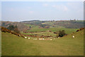
View towards Baker's Hill
View across the valley towards Baker's Hill showing the mixture of sheep pasture and conifer plantation. The road from Rhydycroesau (middle distance) turns into a track around 200m west (left) of here. View from the public footpath from the road between Rhydycroesau & Cefn Canol
Image: © Espresso Addict
Taken: 31 Mar 2007
0.22 miles
4
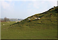
Sheep on hillock
Sheep pasture at around 300m elevation. The rise on the right is the eastern end of the ridge of an unnamed 320m hill north west of Rhydycroesau whose summit lies in Image
Image: © Espresso Addict
Taken: 31 Mar 2007
0.24 miles