IMAGES TAKEN NEAR TO
Broomhall Close, OSWESTRY, SY10 7HF
Introduction
This page details the photographs taken nearby to Broomhall Close, SY10 7HF by members of the Geograph project.
The Geograph project started in 2005 with the aim of publishing, organising and preserving representative images for every square kilometre of Great Britain, Ireland and the Isle of Man.

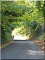
There are currently over 7.5m images from over14,400 individuals and you can help contribute to the project by visiting https://www.geograph.org.uk
Image Map
Images are licensed for reuse under creativecommons.org/licenses/by-sa/2.0
Notes
- Clicking on the map will re-center to the selected point.
- The higher the marker number, the further away the image location is from the centre of the postcode.
Image Listing (11 Images Found)
Images are licensed for reuse under creativecommons.org/licenses/by-sa/2.0
Image
Details
Distance
1
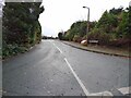
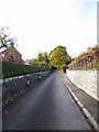
Junction of Broom Hall Close and Broomhall Lane
For some reason the spelling of Broomhall is different here.
Image: © Eric Marsh
Taken: 5 Dec 2021
0.03 miles
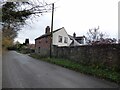
2
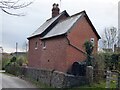
Broom Hall Cottage. Broomhall Lane
Broom Hall Cottage, originally part of the Broom Hall estate.
Image: © Eric Marsh
Taken: 22 Oct 2020
0.04 miles
3
Broom Hall Cottage Broomhall Lane
Once part of the Broomhall estate.
Image: © Eric Marsh
Taken: 5 Dec 2021
0.05 miles
4
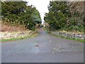
Restricted Byway off Broomhall Lane
The byway goes along the edge of the Water treatment works.
Image: © Eric Marsh
Taken: 5 Dec 2021
0.08 miles
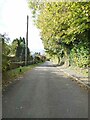
5
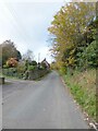
Broomhall Lane
Trees with T.P.O's on them to preserve the leafy nature of the lane.
Image: © Eric Marsh
Taken: 22 Oct 2020
0.09 miles
6
Broomhall Lane
From the junction of Broomhall Lane with Trefonen Road.
Image: © Eric Marsh
Taken: 22 Oct 2020
0.10 miles
7
Rose Cottage. Broomhall Lane
Probably part of the Broomhall estate.
Image: © Eric Marsh
Taken: 5 Dec 2021
0.13 miles
8
Rose cottage. Broomhall Lane
Once part of the Broom Hall Estate.
Image: © Eric Marsh
Taken: 22 Oct 2020
0.22 miles
9
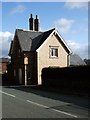
Old Toll House, Upper Brook Street, Oswestry
Toll House in the parish of Oswestry, on Upper Brook Street near Oswald's Well.
Shropshire HER.
HER Number (PRN): 15339 https://www.heritagegateway.org.uk/Gateway/Results_Single.aspx?uid=MSA17242&resourceID=1015
To be surveyed
Milestone Society National ID: SA.OSW02
Image: © Milestone Society
Taken: Unknown
0.23 miles
10
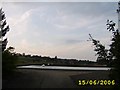
Llanfordda Filter Beds
These filter beds are part of the Lake Vyrnwy to Liverpool Aqueduct.
Image: © Mr M Evison
Taken: 15 Jun 2006
0.23 miles