IMAGES TAKEN NEAR TO
Bath Banks, OSWESTRY, SY10 7EZ
Introduction
This page details the photographs taken nearby to Bath Banks, SY10 7EZ by members of the Geograph project.
The Geograph project started in 2005 with the aim of publishing, organising and preserving representative images for every square kilometre of Great Britain, Ireland and the Isle of Man.

There are currently over 7.5m images from over14,400 individuals and you can help contribute to the project by visiting https://www.geograph.org.uk
Image Map
Images are licensed for reuse under creativecommons.org/licenses/by-sa/2.0
Notes
- Clicking on the map will re-center to the selected point.
- The higher the marker number, the further away the image location is from the centre of the postcode.
Image Listing (37 Images Found)
Images are licensed for reuse under creativecommons.org/licenses/by-sa/2.0
Image
Details
Distance
1
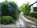
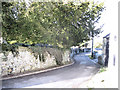
Nant Lane, Selattyn
The sign is an understatement. This is a very narrow lane with a poor surface. After crossing a valley you come to a junction where you need to turn right, but it is so acute and tight that you can't if driving a car (although it might be possible in a small four-wheel drive car). You have to turn left and turn round at The Dingle.
Image: © Humphrey Bolton
Taken: 17 Aug 2019
0.04 miles
2
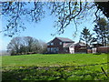
Relatively new houses on the edge of Selattyn
Small development with good views over the Shropshire plain.
Image: © John Haynes
Taken: 2 May 2013
0.04 miles
3
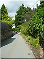
The lane to Weston Rhyn, Selattyn
This is not named on maps, but Nant Lane Image carries straight on at the bottom of the hill, where the 'main' lane turns right.
Image: © Humphrey Bolton
Taken: 17 Aug 2019
0.04 miles
4
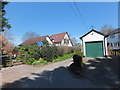
Houses at the end of Nant Lane
These houses are on the northern edge of Selattyn.
Image: © John Haynes
Taken: 2 May 2013
0.04 miles
6
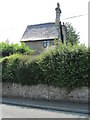
Old Toll House, Selattyn
Toll House by the B4579, in the parish of Selattyn and Gobowen.
To be surveyed
Milestone Society National ID: SA.SEL
Image: © Milestone Society
Taken: Unknown
0.08 miles
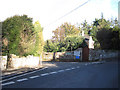
7
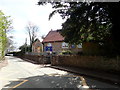
Old road direction signs and bus shelter, Selattyn
The pre-Worboys signs were a nice surprise!
Image: © Humphrey Bolton
Taken: 17 Aug 2019
0.08 miles
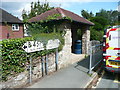
10
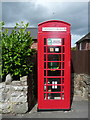
Former telephone kiosk, Selattyn
This has two new uses: it contains a little village library and a defibrillator.
Image: © Humphrey Bolton
Taken: 17 Aug 2019
0.10 miles