IMAGES TAKEN NEAR TO
Nefod Lane, OSWESTRY, SY10 7BA
Introduction
This page details the photographs taken nearby to Nefod Lane, SY10 7BA by members of the Geograph project.
The Geograph project started in 2005 with the aim of publishing, organising and preserving representative images for every square kilometre of Great Britain, Ireland and the Isle of Man.

There are currently over 7.5m images from over14,400 individuals and you can help contribute to the project by visiting https://www.geograph.org.uk
Image Map
Images are licensed for reuse under creativecommons.org/licenses/by-sa/2.0
Notes
- Clicking on the map will re-center to the selected point.
- The higher the marker number, the further away the image location is from the centre of the postcode.
Image Listing (6 Images Found)
Images are licensed for reuse under creativecommons.org/licenses/by-sa/2.0
Image
Details
Distance
1
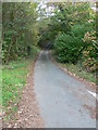
Nefod Lane
Nefod Lane runs alongside Wat's Dyke for a short stretch.
Image: © Eirian Evans
Taken: 23 Oct 2007
0.04 miles
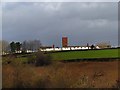
2
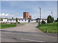
Bank Top Industrial Estate
The aptly named Bank Top Industrial Estate is a small estate near St Martins Moor.
Image: © John Haynes
Taken: 7 May 2006
0.06 miles
3
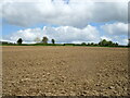
Recently-ploughed field
West of St Martins.
Image: © John H Darch
Taken: 10 May 2021
0.16 miles
4
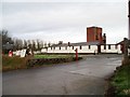
Bank Top Industrial Estate
Formerly a prisoner of war camp.
Image: © Chris Andrews
Taken: 29 Jan 2017
0.17 miles
5
Bank Top Industrial Estate from the SU Canal
Formerly a Prisoner of war camp (Italians) now busy Industrial Estate
Image: © Linnet
Taken: 10 Mar 2011
0.19 miles
6
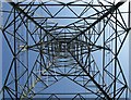
Electricity Pylon
This picture was taken from the base of the pylon towards the top in Rhyn Lane, Rhyn nr. St Martins
Image: © Linnet
Taken: 22 May 2010
0.23 miles