IMAGES TAKEN NEAR TO
Preeshenlle, OSWESTRY, SY10 7AR
Introduction
This page details the photographs taken nearby to Preeshenlle, SY10 7AR by members of the Geograph project.
The Geograph project started in 2005 with the aim of publishing, organising and preserving representative images for every square kilometre of Great Britain, Ireland and the Isle of Man.

There are currently over 7.5m images from over14,400 individuals and you can help contribute to the project by visiting https://www.geograph.org.uk
Image Map
Images are licensed for reuse under creativecommons.org/licenses/by-sa/2.0
Notes
- Clicking on the map will re-center to the selected point.
- The higher the marker number, the further away the image location is from the centre of the postcode.
Image Listing (6 Images Found)
Images are licensed for reuse under creativecommons.org/licenses/by-sa/2.0
Image
Details
Distance
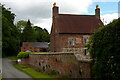
2
Wat's Dyke heading for Gobowen
Wat's Dyke was a 40 mile earthwork running from the River Dee to Maesbury in Shropshire. Much of it is still navigable, some on footpaths and some on country roads. Only traces of the original dyke are now visible.
Image: © John Lucas
Taken: 18 May 2017
0.08 miles
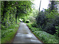
3
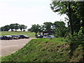
Road to St Martins at Rhewi
Viewed from Preeshenlle Lane entrance
Image: © John Firth
Taken: 23 Nov 2010
0.19 miles
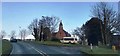
6
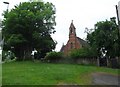
Preeshenlle Golf Club, near Gobowen
Built in the former Hellne Park the golf club looks well on a beautiful July day.
Image: © John Haynes
Taken: 12 Jul 2006
0.22 miles