IMAGES TAKEN NEAR TO
Llanwddyn, OSWESTRY, SY10 0NF
Introduction
This page details the photographs taken nearby to SY10 0NF by members of the Geograph project.
The Geograph project started in 2005 with the aim of publishing, organising and preserving representative images for every square kilometre of Great Britain, Ireland and the Isle of Man.

There are currently over 7.5m images from over14,400 individuals and you can help contribute to the project by visiting https://www.geograph.org.uk
Image Map
Images are licensed for reuse under creativecommons.org/licenses/by-sa/2.0
Notes
- Clicking on the map will re-center to the selected point.
- The higher the marker number, the further away the image location is from the centre of the postcode.
Image Listing (10 Images Found)
Images are licensed for reuse under creativecommons.org/licenses/by-sa/2.0
Image
Details
Distance
1

Eunant House
Off the road that goes up the Eunant Valley toward Dinas Mawddwy, this house was built to replace one drowned under Lake Vyrnwy. It can be let for self-catering holidays. It was a miserable day, hence the car headlights, but I reckon it's beautiful in nice weather.
Image: © Mike White
Taken: 26 Jun 2009
0.01 miles
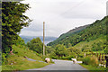
3
Looking over Fridd Fawr from mountain road
Image: © John Firth
Taken: 11 Oct 2010
0.06 miles
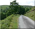
4
Great day, mid Wales at its best
The weather forecast was blustery showers, heavy at times. Magic day, stunning brightly lit views one minute, rain and wind the next. Thought about lightening this photo but no, see it how it was, a grand day out, I wish I could shake off the rain like the sheep do when the sun comes out. The view down the Eunant Fawr towards Llyn Efyrnwy.
Image: © John Haynes
Taken: 28 Oct 2005
0.11 miles
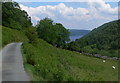
5
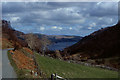
Field in Cwm Eunant
With Lake Vyrnwy / Llyn Efyrnwy in the distance. Taken on the minor road descending from Bwlch y Groes.
Image: © Nigel Brown
Taken: 3 Apr 1991
0.12 miles
6
Dropping down to Pont Eunant and Llyn Efyrnwy, 1993
View east on road down from Bwlch-y-Groes - sheep on the road once again. (Cf. Image).
Image: © Ben Brooksbank
Taken: 17 Jun 1993
0.14 miles
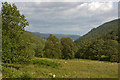
7
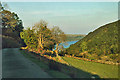
First glimpse of Lake Vyrnwy
The road is descending the River Eunant valley.
Image: © Mat Fascione
Taken: 20 Jun 2012
0.15 miles
8
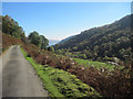
The Eunant valley below Eunant House
A mixture of fields, now morphing into rough grazing, and woodland. Lake Vyrnwy can be seen in the distance.
Image: © Nigel Brown
Taken: 18 Aug 2015
0.19 miles
10
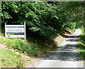
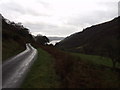
Welcome to Lake Vyrnwy
Along the road that descends along the Eunant Valley, to Lake Vyrnwy at Pont Eunant.
Image: © Mat Fascione
Taken: 20 Jun 2012
0.24 miles