IMAGES TAKEN NEAR TO
Hirnant, Penybontfawr, OSWESTRY, SY10 0HS
Introduction
This page details the photographs taken nearby to SY10 0HS by members of the Geograph project.
The Geograph project started in 2005 with the aim of publishing, organising and preserving representative images for every square kilometre of Great Britain, Ireland and the Isle of Man.

There are currently over 7.5m images from over14,400 individuals and you can help contribute to the project by visiting https://www.geograph.org.uk
Image Map
Images are licensed for reuse under creativecommons.org/licenses/by-sa/2.0
Notes
- Clicking on the map will re-center to the selected point.
- The higher the marker number, the further away the image location is from the centre of the postcode.
Image Listing (7 Images Found)
Images are licensed for reuse under creativecommons.org/licenses/by-sa/2.0
Image
Details
Distance
1
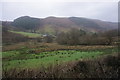
Cwm Hirnant
Looking across the valley on a wet day from the south side.
Image: © Bill Boaden
Taken: 5 Feb 2016
0.03 miles
2
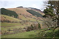
Cwm Hirnant
Looking back down the valley towards Hirnant village as the road begins to climb steeply into the forestry plantations.
Image: © Chris Denny
Taken: 23 Mar 2008
0.10 miles
3
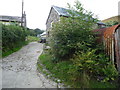
Part of Clochnant farm
A farm above the road.
Image: © Jeremy Bolwell
Taken: 30 Aug 2012
0.18 miles
4
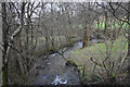
Afon Hirnant
Looking downstream near Hirnant, from where the road crosses the river.
Image: © Bill Boaden
Taken: 5 Feb 2016
0.21 miles
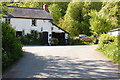
5
Clochnant-bach cottage
A picturesque roadside cottage.
Image: © Jeremy Bolwell
Taken: 30 Aug 2012
0.24 miles
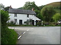
6
Clochnant Bach
At the junction in front of the house, right leads to Hirnant and Penybontfawr, left to Clochnant.
Image: © Trevor Harris
Taken: 3 Jun 2016
0.25 miles
7
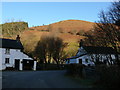
Bythynnod yn Hirnant / Cottages in Hirnant
Haul boreol ar fryniau uwchben Hirnant / Morning sun on the hills above Hirnant
Image: © Ian Medcalf
Taken: 13 Feb 2008
0.25 miles