IMAGES TAKEN NEAR TO
Mordaunt Street, LONDON, SW9 9RB
Introduction
This page details the photographs taken nearby to Mordaunt Street, SW9 9RB by members of the Geograph project.
The Geograph project started in 2005 with the aim of publishing, organising and preserving representative images for every square kilometre of Great Britain, Ireland and the Isle of Man.

There are currently over 7.5m images from over14,400 individuals and you can help contribute to the project by visiting https://www.geograph.org.uk
Image Map
Images are licensed for reuse under creativecommons.org/licenses/by-sa/2.0
Notes
- Clicking on the map will re-center to the selected point.
- The higher the marker number, the further away the image location is from the centre of the postcode.
Image Listing (147 Images Found)
Images are licensed for reuse under creativecommons.org/licenses/by-sa/2.0
Image
Details
Distance
3
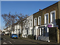
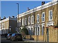
Terraced houses, Hargwyne Street, SW9 (2)
Image: © Mike Quinn
Taken: 17 Jan 2018
0.06 miles
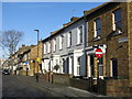
6

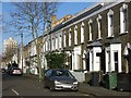
Chantrey Road - Brixton
When I took this photo most houses were still one house, now the former owners have cashed in by converting into flats. Understandable but the character of these fine town houses is lost forever.
Image: © Mr Ignavy
Taken: 17 May 2003
0.08 miles
8
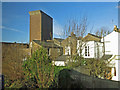
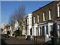
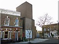
Victoria Line ventilation shaft, Pulross Road, SW9 (5)
Image: © Mike Quinn
Taken: 17 Jan 2018
0.11 miles
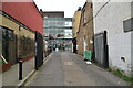
10
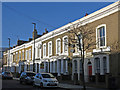
Victoria Line ventilation shaft, Pulross Road, SW9
See also Image
Image: © Mike Quinn
Taken: 17 Jan 2018
0.12 miles