IMAGES TAKEN NEAR TO
Prideaux Road, LONDON, SW9 9LQ
Introduction
This page details the photographs taken nearby to Prideaux Road, SW9 9LQ by members of the Geograph project.
The Geograph project started in 2005 with the aim of publishing, organising and preserving representative images for every square kilometre of Great Britain, Ireland and the Isle of Man.

There are currently over 7.5m images from over14,400 individuals and you can help contribute to the project by visiting https://www.geograph.org.uk
Image Map (Loading...)


Getting Data...Please wait
Leaflet Map data © OpenStreetMap
Images are licensed for reuse under creativecommons.org/licenses/by-sa/2.0
Notes
- Clicking on the map will re-center to the selected point.
- The higher the marker number, the further away the image location is from the centre of the postcode.
Image Listing (176 Images Found)
Images are licensed for reuse under creativecommons.org/licenses/by-sa/2.0
Image
Details
Distance
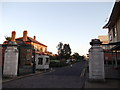
1

The Light and Full Gospel Fellowship, Brixton
A group of houses on Landor Road have been converted into a modern church.
Image: © David Anstiss
Taken: 2 Oct 2011
0.03 miles
2
Entrance to South Western Hospital
Formal entrance on Landor Road to a modern hospital.
Image: © David Anstiss
Taken: 2 Oct 2011
0.06 miles
3
Tasman Road, Clapham
Seen from the junction with Landor Road; Tasman Road forks, with Andalus Road leading off to the left.
Image: © Stephen McKay
Taken: 29 May 2009
0.07 miles
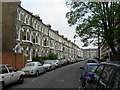
4

Stockwell: Mayflower Road
Apart from the cars, this street would not have appeared very different a century ago.
Image: © Dr Neil Clifton
Taken: 11 Jul 2012
0.10 miles
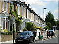
5
Mayflower Road SW9
There are a lot of these tall terraced houses here. None of these houses would have been built with any thought of car parking, and spaces are clearly at a premium. Flat conversions are quite common with these types of building, further compounding the problem.
Image: © Danny P Robinson
Taken: 9 May 2006
0.10 miles
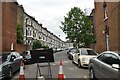
7
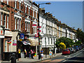
Landor Road, Clapham
Typical south London architecture on the north side of Landor Road, seen from the junction with Atherfold Road.
Image: © Stephen McKay
Taken: 29 May 2009
0.13 miles
8
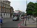
Clapham Road SW9
Taken at the junction of Mayflower Road. It is around 5pm and the queuing traffic is headed away from the centre of London. This is the A3, a major route to the south west of the city and beyond. It has been designated a "Red Route" (a road with extra parking restrictions and enhanced enforcement for parking infringements), hence the red double lines at the kerbside.
Image: © Danny P Robinson
Taken: 9 May 2006
0.14 miles
9
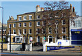
359-361 Clapham Road
A pair of substantial early C19th houses, both of four storeys, no. 361 five bays wide and no. 359 three bays wide plus a two-bay extension with a bow. Grade II listed.
Part of a group of houses on the east side of Clapham Road running north from Landor Road built on land which came into the ownership of the Duke of Bedford in the early C18th. The Survey of London records that building began after he signed an agreement with Archer Willson, a builder of Fulham, in 1791.
Image: © Stephen Richards
Taken: 11 Mar 2012
0.14 miles
10
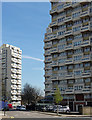
Beckett, Arden and Pinter Houses, Grantham Road
Three of several tower blocks whose jagged profiles are a notable landmark on Lambeth's skyline. These date from c1969 and were designed by Lambeth Architect's Department.
Image: © Stephen Richards
Taken: 21 Apr 2013
0.15 miles