IMAGES TAKEN NEAR TO
Stirling Road, LONDON, SW9 9EF
Introduction
This page details the photographs taken nearby to Stirling Road, SW9 9EF by members of the Geograph project.
The Geograph project started in 2005 with the aim of publishing, organising and preserving representative images for every square kilometre of Great Britain, Ireland and the Isle of Man.

There are currently over 7.5m images from over14,400 individuals and you can help contribute to the project by visiting https://www.geograph.org.uk
Image Map
Images are licensed for reuse under creativecommons.org/licenses/by-sa/2.0
Notes
- Clicking on the map will re-center to the selected point.
- The higher the marker number, the further away the image location is from the centre of the postcode.
Image Listing (161 Images Found)
Images are licensed for reuse under creativecommons.org/licenses/by-sa/2.0
Image
Details
Distance
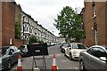
2

Stockwell: Mayflower Road
Apart from the cars, this street would not have appeared very different a century ago.
Image: © Dr Neil Clifton
Taken: 11 Jul 2012
0.03 miles
3
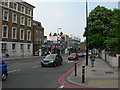
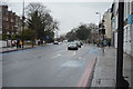
Clapham Road SW9
Taken at the junction of Mayflower Road. It is around 5pm and the queuing traffic is headed away from the centre of London. This is the A3, a major route to the south west of the city and beyond. It has been designated a "Red Route" (a road with extra parking restrictions and enhanced enforcement for parking infringements), hence the red double lines at the kerbside.
Image: © Danny P Robinson
Taken: 9 May 2006
0.04 miles
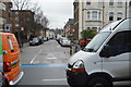
5

Stockwell: Clitheroe Road
Looking southeast from its junction with Clapham Road, at which end the junction is closed to vehicular traffic as a traffic-calming measure. One of the small pockets in which first-generation housing still survives, albeit in multi-occupation.
Image: © Dr Neil Clifton
Taken: 11 Jul 2012
0.06 miles
6

Block of flats, corner of Mayflower Road and Clapham Road
Image: © David Smith
Taken: 17 Nov 2016
0.06 miles
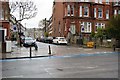
9
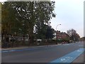
Houses and flats in Clapham Road
The flats are set back from this (normally) busy road behind the trees on the left. The road is marked with a cycle path
Image: © David Smith
Taken: 28 Nov 2013
0.07 miles
10
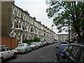
Mayflower Road SW9
There are a lot of these tall terraced houses here. None of these houses would have been built with any thought of car parking, and spaces are clearly at a premium. Flat conversions are quite common with these types of building, further compounding the problem.
Image: © Danny P Robinson
Taken: 9 May 2006
0.07 miles