IMAGES TAKEN NEAR TO
Ferndale Road, LONDON, SW9 8BA
Introduction
This page details the photographs taken nearby to Ferndale Road, SW9 8BA by members of the Geograph project.
The Geograph project started in 2005 with the aim of publishing, organising and preserving representative images for every square kilometre of Great Britain, Ireland and the Isle of Man.

There are currently over 7.5m images from over14,400 individuals and you can help contribute to the project by visiting https://www.geograph.org.uk
Image Map
Images are licensed for reuse under creativecommons.org/licenses/by-sa/2.0
Notes
- Clicking on the map will re-center to the selected point.
- The higher the marker number, the further away the image location is from the centre of the postcode.
Image Listing (354 Images Found)
Images are licensed for reuse under creativecommons.org/licenses/by-sa/2.0
Image
Details
Distance
2
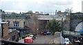
Nursery Road, Brixton, from the train
Image: © Christopher Hilton
Taken: 3 Jun 2011
0.03 miles
6
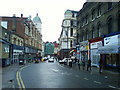
Ferndale Road, SW9 (2)
Looking towards Brixton Road.
Image: © Danny P Robinson
Taken: 23 Feb 2007
0.05 miles
8
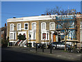
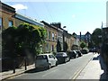
Terraced houses, Pulross Road / Bellefields Road, SW9
Image: © Mike Quinn
Taken: 17 Jan 2018
0.05 miles
10
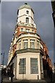
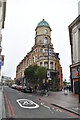
Brixton Post Office
The building, with a copper dome, occupies a wedge-shaped site between Ferndale Road (left) and Stockwell Avenue.
Image: © Derek Harper
Taken: 11 Mar 2011
0.06 miles