IMAGES TAKEN NEAR TO
Sisulu Place, LONDON, SW9 7NW
Introduction
This page details the photographs taken nearby to Sisulu Place, SW9 7NW by members of the Geograph project.
The Geograph project started in 2005 with the aim of publishing, organising and preserving representative images for every square kilometre of Great Britain, Ireland and the Isle of Man.

There are currently over 7.5m images from over14,400 individuals and you can help contribute to the project by visiting https://www.geograph.org.uk
Image Map
Images are licensed for reuse under creativecommons.org/licenses/by-sa/2.0
Notes
- Clicking on the map will re-center to the selected point.
- The higher the marker number, the further away the image location is from the centre of the postcode.
Image Listing (199 Images Found)
Images are licensed for reuse under creativecommons.org/licenses/by-sa/2.0
Image
Details
Distance
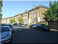
1
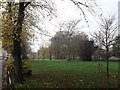
Max Roach Park, Brixton
As seen from St.John's Crescent.
This park is named after an American jazz percussionist, drummer, and composer.
It was opened by him in 1986.
See http://en.wikipedia.org/wiki/Max_Roach for more details about the composer.
Image: © David Anstiss
Taken: 20 Nov 2011
0.07 miles
2
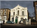
Karibu Centre
The Karibu Education Centre occupies this attractive classical former chapel on Gresham Road in Brixton.
Image: © Derek Harper
Taken: 11 Mar 2011
0.07 miles
3
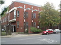
Brixton Telephone Exchange
Located at 45 Gresham Road, this TE used to have BRIxton and REDpost numbers until the late 1960s. Besides Brixton, this TE also serves Herne Hill nearby, and now has 0207-274, 733, 737 and 926 numbers. Looking at the brickwork and windows, this TE would appear to have been rebuilt quite recently. Its postcode is SW9 7NU.
Image: © David Hillas
Taken: 4 Oct 2011
0.09 miles
4
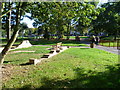
Max Roach Park
Max Roach Park consists of four small open spaces along the eastern side of Brixton Road from Brixton to Angell Town. The park is built on land originally occupied by shops and housing and is named after Max Roach, an internationally famous jazz percussionist and composer. This part of the park between Villa Road and St John's Crescent is the largest part, and also the closest to Brixton Town Centre. The houses beyond the park are in St John's Crescent. I presume the bricks came from the original buildings or are maybe meant to show the footprint of an original building. The River Effra once ran along the eastern side of Brixton Road here and was described in the mid 19th century as "being protected by a handrail and crossed by small wooden bridges leading to the gardens of the houses scattered along its banks. The profusion of lilac, hawthorn and laburnum which grew on the river bank made this part of Brixton Road beautiful in the springtime." Within a few years though the Effra had been bricked over.
Image: © Marathon
Taken: 28 Sep 2011
0.09 miles
6
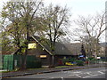
Max Roach Children's Centre, Brixton
This large log cabin on Wiltshire Road is used as a day centre and playgroup club. It is on the edge of Max Roach Park. Named after an American jazz percussionist, drummer, and composer.
Image: © David Anstiss
Taken: 20 Nov 2011
0.10 miles
7

Max Roach Park
Max Roach Park consists of four small open spaces along the eastern side of Brixton Road from Brixton to Angell Town. The park is built on land originally occupied by shops and housing and is named after Max Roach, an internationally famous jazz percussionist and composer. This part of the park between Villa Road and St John's Crescent is the largest part, and also the closest to Brixton Town Centre. I presume the bricks came from the original buildings.
The River Effra once ran along the eastern side of Brixton Road here and was described in the mid 19th century as "being protected by a handrail and crossed by small wooden bridges leading to the gardens of the houses scattered along its banks. The profusion of lilac, hawthorn and laburnum which grew on the river bank made this part of Brixton Road beautiful in the springtime." Within a few years though the Effra had been bricked over.
Image: © Marathon
Taken: 28 Sep 2011
0.10 miles
8
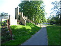
Path in Max Roach Park
Max Roach Park consists of four small open spaces along the eastern side of Brixton Road from Brixton to Angell Town. The park is built on land originally occupied by shops and housing and is named after Max Roach, an internationally famous jazz percussionist and composer. This part of the park between Villa Road and St John's Crescent is the largest part, and also the closest to Brixton Town Centre. I presume the bricks came from the original buildings. The River Effra once ran along the eastern side of Brixton Road here (parallel with the right hand side of this path) and was described in the mid 19th century as "being protected by a handrail and crossed by small wooden bridges leading to the gardens of the houses scattered along its banks. The profusion of lilac, hawthorn and laburnum which grew on the river bank made this part of Brixton Road beautiful in the springtime." Within a few years though the Effra had been bricked over.
Image: © Marathon
Taken: 28 Sep 2011
0.11 miles
9
337 Brixton Road, Brixton
Grade II listed house on the A23.
See http://www.britishlistedbuildings.co.uk/en-204028-337-and-339-brixton for more details on the house.
Image: © David Anstiss
Taken: 20 Nov 2011
0.11 miles
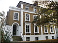
10
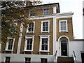
339 Brixton Road, Brixton
Grade II listed house on the A23.
Attached to Image (on the left, another listed building).
See http://www.britishlistedbuildings.co.uk/en-204028-337-and-339-brixton for more details on the house.
Image: © David Anstiss
Taken: 20 Nov 2011
0.11 miles