
IMAGES TAKEN NEAR TO
Brixton Road, LONDON, SW9 7BW
Introduction
This page details the photographs taken nearby to Brixton Road, SW9 7BW by members of the Geograph project.
The Geograph project started in 2005 with the aim of publishing, organising and preserving representative images for every square kilometre of Great Britain, Ireland and the Isle of Man.

There are currently over 7.5m images from over14,400 individuals and you can help contribute to the project by visiting https://www.geograph.org.uk
Image Map
Images are licensed for reuse under creativecommons.org/licenses/by-sa/2.0
Notes
- Clicking on the map will re-center to the selected point.
- The higher the marker number, the further away the image location is from the centre of the postcode.
Image Listing (175 Images Found)
Images are licensed for reuse under creativecommons.org/licenses/by-sa/2.0
Image
Details
Distance
1
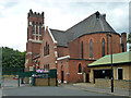
Catholic church, Brixton
Our Lady of the Rosary church was built as an Independent Church in 1870. It was repaired after heavy war damage and converted to Catholic use, opening as such in 1953. This is a rear view - it fronts Brixton Road.
Image: © Robin Webster
Taken: 23 Jul 2011
0.01 miles
2
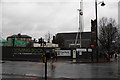
The Park: development site on Stockwell Park Walk
The new homes will be built on the site of demolished blocks of flats.
Image: © Bill Boaden
Taken: 31 Jan 2014
0.03 miles
3
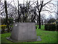
First Child sculpture in Max Roach Park, Brixton
First Child is one of a very few pieces of contemporary artwork in this area of London. It was designed and made by sculptor Raymond Watson and has been a pleasing fixture on the edge of this park since 1994. The piece is designed to show the joy and happiness of having a child but also the great responsibility and fragility this can cause within the parent.
Image: © PAUL FARMER
Taken: 26 Feb 2011
0.03 miles
4
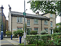
The Friendly Almshouses
One block of several along here, although some are more older and more attractive than this one. The Friendly Almshouses was originally established in 1802 as the Female Friendly Society. Only female residents are accepted.
Image: © Robin Webster
Taken: 23 Jul 2011
0.03 miles
5
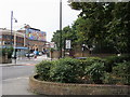
Mural on Brixton academy
Looking out from Max Roach park across the Brixton road to the mural on the rear wall of Brixton academy
Image: © Shaun Ferguson
Taken: 18 Sep 2008
0.04 miles
6
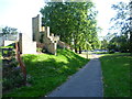
Path in Max Roach Park
Max Roach Park consists of four small open spaces along the eastern side of Brixton Road from Brixton to Angell Town. The park is built on land originally occupied by shops and housing and is named after Max Roach, an internationally famous jazz percussionist and composer. This part of the park between Villa Road and St John's Crescent is the largest part, and also the closest to Brixton Town Centre. I presume the bricks came from the original buildings. The River Effra once ran along the eastern side of Brixton Road here (parallel with the right hand side of this path) and was described in the mid 19th century as "being protected by a handrail and crossed by small wooden bridges leading to the gardens of the houses scattered along its banks. The profusion of lilac, hawthorn and laburnum which grew on the river bank made this part of Brixton Road beautiful in the springtime." Within a few years though the Effra had been bricked over.
Image: © Marathon
Taken: 28 Sep 2011
0.04 miles
7
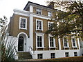
337 Brixton Road, Brixton
Grade II listed house on the A23.
See http://www.britishlistedbuildings.co.uk/en-204028-337-and-339-brixton for more details on the house.
Image: © David Anstiss
Taken: 20 Nov 2011
0.04 miles
8
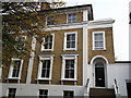
339 Brixton Road, Brixton
Grade II listed house on the A23.
Attached to Image (on the left, another listed building).
See http://www.britishlistedbuildings.co.uk/en-204028-337-and-339-brixton for more details on the house.
Image: © David Anstiss
Taken: 20 Nov 2011
0.04 miles
9
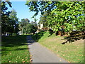
Path in Max Roach Park
Max Roach Park consists of four small open spaces along the eastern side of Brixton Road from Brixton to Angell Town. The park is built on land originally occupied by shops and housing and is named after Max Roach, an internationally famous jazz percussionist and composer. This part of the park between Villa Road and St John's Crescent is the largest part, and also the closest to Brixton Town Centre. The River Effra once ran along the eastern side of Brixton Road here (to the left of this path) and was described in the mid 19th century as "being protected by a handrail and crossed by small wooden bridges leading to the gardens of the houses scattered along its banks. The profusion of lilac, hawthorn and laburnum which grew on the river bank made this part of Brixton Road beautiful in the springtime." Within a few years though the Effra had been bricked over.
Image: © Marathon
Taken: 28 Sep 2011
0.04 miles
10
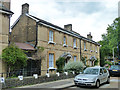
The Friendly Almshouses
One block of several along here, although some are more modern and less attractive. The Friendly Almshouses was originally established in 1802 as the Female Friendly Society. Only female residents are accepted.
Image: © Robin Webster
Taken: 23 Jul 2011
0.05 miles