IMAGES TAKEN NEAR TO
Cromwell Road, LONDON, SW9 7BH
Introduction
This page details the photographs taken nearby to Cromwell Road, SW9 7BH by members of the Geograph project.
The Geograph project started in 2005 with the aim of publishing, organising and preserving representative images for every square kilometre of Great Britain, Ireland and the Isle of Man.

There are currently over 7.5m images from over14,400 individuals and you can help contribute to the project by visiting https://www.geograph.org.uk
Image Map
Images are licensed for reuse under creativecommons.org/licenses/by-sa/2.0
Notes
- Clicking on the map will re-center to the selected point.
- The higher the marker number, the further away the image location is from the centre of the postcode.
Image Listing (162 Images Found)
Images are licensed for reuse under creativecommons.org/licenses/by-sa/2.0
Image
Details
Distance
5
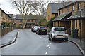
Myatt Road, Brixton
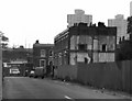
Myatt Road was on its last legs in October 1978. These are the last few houses awaiting the bulldozer.
Myatt Road ran between Patmos Road and Langton Road. This is the Langton Road end. The flats in the background are in Wyndham Road (Brandon Estate).
I am indebted to David Hughes for this information
Image: © Dr Neil Clifton
Taken: 15 Oct 1978
0.08 miles
6
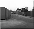
Myatt Road, Camberwell
Taken from the junction with Patmos Road. Most of the houses in Myatt Road had been demolished before this photograph was taken. The few that remained soon followed.
Image: © Dr Neil Clifton
Taken: 15 Oct 1978
0.08 miles
7
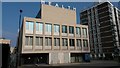
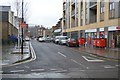
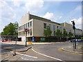
Akerman Health Centre
Part of the new Oval Quarter development.
Image: © David Martin
Taken: 11 Mar 2016
0.09 miles
8
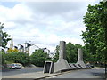
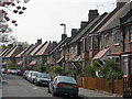
Akerman Road, SW9
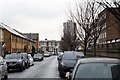
Akerman Road passes through the Myatts Fields housing estate. The estate was built with a communal heating system. This structure in the centre of the road comprises air ventilation shafts and access to the boiler room.
Visible in the centre of the image, to the left of the ventilation shaft, is the top of a tower block on Brandon Estate (see Image), while further in the distance behind it, the three circles are at the top of the Strata tower, a newly-built tower block at Elephant & Castle (see Image).
Image: © Malc McDonald
Taken: 30 May 2011
0.09 miles
10
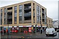
Camberwell, Akerman Health Centre
At the corner of Akerman and Patmos Roads: http://www.akermanmedicalpractice.com/
Image: © Mike Faherty
Taken: 24 Jun 2014
0.09 miles