IMAGES TAKEN NEAR TO
Normandy Road, LONDON, SW9 6JH
Introduction
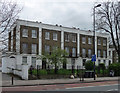
This page details the photographs taken nearby to Normandy Road, SW9 6JH by members of the Geograph project.
The Geograph project started in 2005 with the aim of publishing, organising and preserving representative images for every square kilometre of Great Britain, Ireland and the Isle of Man.

There are currently over 7.5m images from over14,400 individuals and you can help contribute to the project by visiting https://www.geograph.org.uk
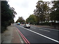
Image Map
Images are licensed for reuse under creativecommons.org/licenses/by-sa/2.0
Notes
- Clicking on the map will re-center to the selected point.
- The higher the marker number, the further away the image location is from the centre of the postcode.
Image Listing (114 Images Found)
Images are licensed for reuse under creativecommons.org/licenses/by-sa/2.0
Image
Details
Distance
1
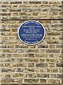
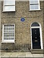
Cherry Dorothy Groce Memorial
Cherry Dorothy Groce
1948-2011
Innocently shot in this house by police which sparked the
1985 Brixton uprising.
A heroine to her children, family and community with her spiritual strength, motivation, optimism and love
Her legacy lives on
Cherry Tree Trust
Lambeth Council
Image: © Jack
Taken: 15 Apr 2023
0.02 miles
2
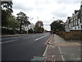
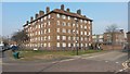
Street view of Cherry Dorothy Groce Memorial
Cherry Dorothy Groce
1948-2011
Innocently shot in this house by police which sparked the
1985 Brixton uprising.
A heroine to her children, family and community with her spiritual strength, motivation, optimism and love
Her legacy lives on
Cherry Tree Trust
Lambeth Council
Image: © Jack
Taken: 15 Apr 2023
0.02 miles
3
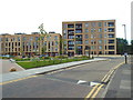
Long-established housing on the edge of Oval Quarter development
Image: © David Martin
Taken: 11 Mar 2016
0.02 miles
4
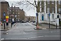
Cowley Road, near Brixton
Cowley Road, with a recently-completed housing development.
Image: © Malc McDonald
Taken: 9 Jul 2016
0.04 miles
5
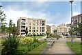
Housing round a park
A recent development of apartments around a central square.
Image: © Des Blenkinsopp
Taken: 23 May 2024
0.05 miles
6
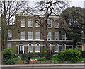
195-203 Brixton Road
A terrace of five houses, each divided by panelled pilasters. Probably built after the construction of Vauxhall Bridge in 1816 which acted as a spur to local development. Grade II listed.
Image: © Stephen Richards
Taken: 27 Apr 2013
0.05 miles
7
209-211 Brixton Road
A pair of early C19th houses, three-storeys and bays, probably built after the construction of Vauxhall Bridge in 1816 which acted as a spur to local development. Grade II listed.
Interesting contorted tree in front.
Image: © Stephen Richards
Taken: 27 Apr 2013
0.06 miles