IMAGES TAKEN NEAR TO
Stockwell Park Road, LONDON, SW9 0UX
Introduction
This page details the photographs taken nearby to Stockwell Park Road, SW9 0UX by members of the Geograph project.
The Geograph project started in 2005 with the aim of publishing, organising and preserving representative images for every square kilometre of Great Britain, Ireland and the Isle of Man.

There are currently over 7.5m images from over14,400 individuals and you can help contribute to the project by visiting https://www.geograph.org.uk
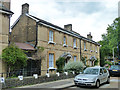
Image Map
Images are licensed for reuse under creativecommons.org/licenses/by-sa/2.0
Notes
- Clicking on the map will re-center to the selected point.
- The higher the marker number, the further away the image location is from the centre of the postcode.
Image Listing (150 Images Found)
Images are licensed for reuse under creativecommons.org/licenses/by-sa/2.0
Image
Details
Distance
1
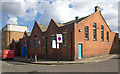
Royal Mail delivery office, Stockwell
Edwardian sorting office, built c.1904.
Image: © Jim Osley
Taken: 21 Mar 2014
0.04 miles
2
Lambeth Accord, 336 Brixton Road
Lambeth Accord positively encourages people with disabilities. They support them through employment, providing affordable office space and through our choice of contractors.
Image: © PAUL FARMER
Taken: 26 Feb 2011
0.05 miles
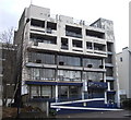
3
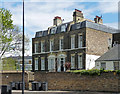
336-340 Brixton Road
No. 340 is an early or mid C19th villa. Grade II listed.
Its neighbour is an interesting, if tatty, piece of 1960s/1970s architecture which deserves a lick of paint.
Image: © Stephen Richards
Taken: 27 Apr 2013
0.05 miles
4
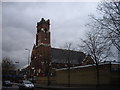
Our Lady of the Rosary, Brixton Road, Brixton
The church opened 1905 as St Helen Independent Church it was acquired and converted for Catholic use 1953.
Image: © PAUL FARMER
Taken: 26 Feb 2011
0.07 miles
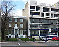
5
309-313 Brixton Road
One of very few pre-1850 survivals on the east side of Brixton Road. Probably originally two houses, now converted to flats. Grade II listed.
Image: © Stephen Richards
Taken: 27 Apr 2013
0.08 miles
6
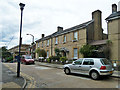
The Friendly Almshouses
One block of several along here, although some are more modern and less attractive, such as just to the left of this row. The Friendly Almshouses was originally established in 1802 as the Female Friendly Society. Only female residents are accepted.
Image: © Robin Webster
Taken: 23 Jul 2011
0.09 miles
7
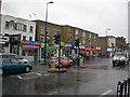
Shops on Brixton Road, SW9
Near Thornton Street.
Image: © Danny P Robinson
Taken: 28 Sep 2007
0.10 miles
9
The Friendly Almshouses
One block of several along here, although some are more modern and less attractive. The Friendly Almshouses was originally established in 1802 as the Female Friendly Society. Only female residents are accepted.
Image: © Robin Webster
Taken: 23 Jul 2011
0.10 miles
10
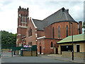
Catholic church, Brixton
Our Lady of the Rosary church was built as an Independent Church in 1870. It was repaired after heavy war damage and converted to Catholic use, opening as such in 1953. This is a rear view - it fronts Brixton Road.
Image: © Robin Webster
Taken: 23 Jul 2011
0.10 miles