IMAGES TAKEN NEAR TO
Robsart Street, LONDON, SW9 0AE
Introduction
This page details the photographs taken nearby to Robsart Street, SW9 0AE by members of the Geograph project.
The Geograph project started in 2005 with the aim of publishing, organising and preserving representative images for every square kilometre of Great Britain, Ireland and the Isle of Man.

There are currently over 7.5m images from over14,400 individuals and you can help contribute to the project by visiting https://www.geograph.org.uk
Image Map
Images are licensed for reuse under creativecommons.org/licenses/by-sa/2.0
Notes
- Clicking on the map will re-center to the selected point.
- The higher the marker number, the further away the image location is from the centre of the postcode.
Image Listing (133 Images Found)
Images are licensed for reuse under creativecommons.org/licenses/by-sa/2.0
Image
Details
Distance
1
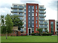
Flats, Robsart Street
Seen from Slade Gardens.
Image: © Robin Webster
Taken: 23 Jul 2011
0.01 miles
2
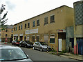
Lambeth Trade Union Resource Centre
Also placarded as the Lambeth T.U.C. Unemployed Workers Centre, this building appears to be disused.
Image: © Robin Webster
Taken: 23 Jul 2011
0.02 miles
3
Dudley House on Robsart Street, Stockwell
Image: © David Howard
Taken: 27 Mar 2022
0.03 miles
5
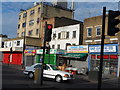
Shops at the corner of Loughborough Road and Brixton Road
Image: © Bikeboy
Taken: 24 Jul 2013
0.05 miles
6
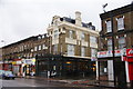
Crown & Anchor, Brixton
A pub listed in the Good Beer Guide. There are not many competitors locally.
Image: © Bill Boaden
Taken: 31 Jan 2014
0.05 miles
8
Wayland House
Seen across Slade Gardens.
Image: © Robin Webster
Taken: 23 Jul 2011
0.06 miles
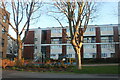
9
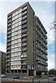
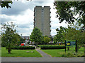
Stockwell Park Estate, Robsart Street
This is Wayland House, dating from c1965, possibly designed by Lambeth Architects' Department. Otherwise the estate is comprised of four-storey blocks of maisonette.
Permission has been granted for its demolition and replacement by a new, taller tower which has proved controversial with some local residents.
Image: © Stephen Richards
Taken: 21 Apr 2012
0.06 miles
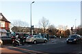
10
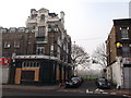
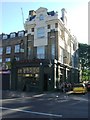
Crown and Anchor Public House, Brixton
Closed public house on the junction of Brixton Road (in front) and Ingleton Street (on the right). Now converted to housing.
See Image, when the pub was a pub!
Ingleton Street leads to Slade Gardens.
Image: © David Anstiss
Taken: 20 Nov 2011
0.06 miles