IMAGES TAKEN NEAR TO
Nine Elms Lane, LONDON, SW8 5DB
Introduction
This page details the photographs taken nearby to Nine Elms Lane, SW8 5DB by members of the Geograph project.
The Geograph project started in 2005 with the aim of publishing, organising and preserving representative images for every square kilometre of Great Britain, Ireland and the Isle of Man.

There are currently over 7.5m images from over14,400 individuals and you can help contribute to the project by visiting https://www.geograph.org.uk
Image Map
Images are licensed for reuse under creativecommons.org/licenses/by-sa/2.0
Notes
- Clicking on the map will re-center to the selected point.
- The higher the marker number, the further away the image location is from the centre of the postcode.
Image Listing (391 Images Found)
Images are licensed for reuse under creativecommons.org/licenses/by-sa/2.0
Image
Details
Distance
1
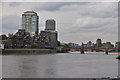
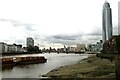
London : Battersea - River Thames
Looking up the River Thames towards Vauxhall Bridge and towards where the river meanders.
Image: © Lewis Clarke
Taken: 13 May 2011
0.02 miles
2
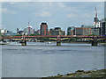
The River Thames
Looking downstream to Vauxhall Bridge from William Henry Walk.
Image: © Thomas Nugent
Taken: 19 May 2014
0.02 miles
3
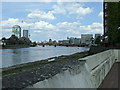
The River Thames
Looking downstream to Vauxhall Bridge from William Henry Walk.
Image: © Thomas Nugent
Taken: 19 May 2014
0.02 miles
6
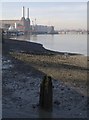
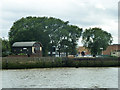
Thames shore at Bourne Valley Wharf
A relic of a former wooden structure - a jetty perhaps - on the muddy south bank of the Thames near Nine Elms Lane. In the distance is Battersea Power Station.
Image: © Derek Harper
Taken: 16 Nov 2007
0.02 miles
7
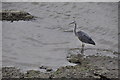
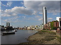
London : Battersea - Heron on the River Thames
Looking down towards the river towards a heron on the riverbank.
Image: © Lewis Clarke
Taken: 13 May 2011
0.03 miles
8
Mudlarking along the River Thames
Taken to the west of Vauxhall Bridge.
Image: © Ian S
Taken: 2 Mar 2014
0.03 miles
9
Bourne Valley Wharf, Nine Elms
In the middle is signs of a small filled in dock, shown as about the size of one barge on old maps. The Bourne Valley Wharf was to the right of this, and to the left was a coal wharf.
Image: © Robin Webster
Taken: 11 Aug 2011
0.03 miles
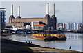
10
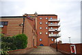
Riverside path and development off Nine Elms Lane
Route of the Thames path.
Image: © N Chadwick
Taken: 25 Aug 2010
0.03 miles