IMAGES TAKEN NEAR TO
St. Josephs Street, LONDON, SW8 4DN
Introduction
This page details the photographs taken nearby to St. Josephs Street, SW8 4DN by members of the Geograph project.
The Geograph project started in 2005 with the aim of publishing, organising and preserving representative images for every square kilometre of Great Britain, Ireland and the Isle of Man.

There are currently over 7.5m images from over14,400 individuals and you can help contribute to the project by visiting https://www.geograph.org.uk
Image Map
Images are licensed for reuse under creativecommons.org/licenses/by-sa/2.0
Notes
- Clicking on the map will re-center to the selected point.
- The higher the marker number, the further away the image location is from the centre of the postcode.
Image Listing (339 Images Found)
Images are licensed for reuse under creativecommons.org/licenses/by-sa/2.0
Image
Details
Distance
1
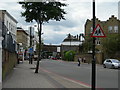
Battersea Park Road SW8
Looking towards Battersea Park train station, with the Rollo and Doddington Estate in the background.
Image: © Danny P Robinson
Taken: 1 Aug 2006
0.03 miles
2
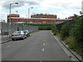
Lockington Road SW8
Looking towards a self-storage warehouse. The railway from London Waterloo runs at right angles to this road, at the end.
Image: © Danny P Robinson
Taken: 1 Aug 2006
0.03 miles
3
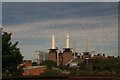
Buildings with a view of Battersea Power Station
Image: © Chris
Taken: 17 Jul 2017
0.04 miles
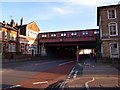
4
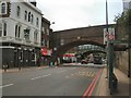
Rail Bridges - Battersea
Crossing Battersea Park Road south of Battersea Park Station
Image: © Paul Gillett
Taken: 14 Jun 2012
0.05 miles
5
Queenstown Road in Battersea
Note the station was formerly named Queens Road
Image: © tristan forward
Taken: 3 Feb 2011
0.05 miles
6
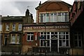
Queenstown Road station
Formerly Queens Road on the London and South-Western railway.
Image: © Christopher Hilton
Taken: 5 Mar 2009
0.05 miles
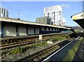
7

Looking north from Queenstown Road station
Queenstown Road station has dwindled over the years to a single island platform, with other platforms now disused.
The viaduct on the right carries lines from Brixton towards Victoria. In the distance, centre, is Battersea Park station.
Image: © Christopher Hilton
Taken: 19 May 2014
0.05 miles
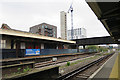
8

Queenstown Road Station
The original name is shown in the tiles: LSWR stands for London and South Western Railway.
Image: © David Martin
Taken: 4 Feb 2013
0.05 miles
9
Where's that fox? Derelict Platform 1, Queenstown Road station
A minute or so earlier, I'd seen a fox sniffing around on the disused platform. It sneaked off below the blue screening at the far end of the platform. I waited for a while, hoping that it would re-emerge, but it didn't.
I don't think I've ever seen a fox quite so close to central London. But I'm reminded that the first foxes I ever saw in London - some years before they became widespread - were living by the railway line just east of Hampstead Heath station. Railway cuttings and embankments can make pretty good 'linear habitats', allowing wildlife to penetrate new territory and then settle. But that explanation can't apply here. The many railway lines that criss-cross the area all run well above street level, carried on continuous viaducts without margins of waste-ground.
Queenstown Road is the last-but-one station on the route into Waterloo. The bridge seen at the far end of the platforms carries one of the lines out of Victoria.
Image: © Stefan Czapski
Taken: 17 Nov 2021
0.05 miles
10
Queenstown Road Station
Looking up the line towards Waterloo.
Image: © Anne Burgess
Taken: 29 Mar 2017
0.05 miles