IMAGES TAKEN NEAR TO
St. Philip Street, LONDON, SW8 3SR
Introduction
This page details the photographs taken nearby to St. Philip Street, SW8 3SR by members of the Geograph project.
The Geograph project started in 2005 with the aim of publishing, organising and preserving representative images for every square kilometre of Great Britain, Ireland and the Isle of Man.

There are currently over 7.5m images from over14,400 individuals and you can help contribute to the project by visiting https://www.geograph.org.uk
Image Map (52 Images)


Getting Data...Please wait
Leaflet Map data © OpenStreetMap
Images are licensed for reuse under creativecommons.org/licenses/by-sa/2.0
Notes
- Clicking on the map will re-center to the selected point.
- The higher the marker number, the further away the image location is from the centre of the postcode.
Image Listing (52 Images Found)
Images are licensed for reuse under creativecommons.org/licenses/by-sa/2.0
Image
Details
Distance
2
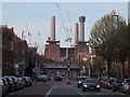
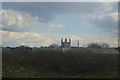
Queenstown Road
The chimneys of Battersea Power Station dominate the view north-north-eastwards up Queenstown Road.
Image: © Anne Burgess
Taken: 26 Mar 2017
0.05 miles
3
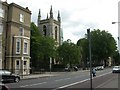
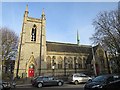
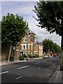
Battersea, St Philip's Church
Former parish church on Queenstown Road. http://www.southwark.anglican.org/downloads/lostchurches/BAT17.pdf Now owned by the Ethiopian Orthodox Church http://www.debretsionlondon.org/
Image: © Mike Faherty
Taken: 22 Aug 2009
0.05 miles
4
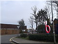
Battersea Studios
An access road leads from Silverthorn Road towards the modern studios.
On the right are part of Stewarts Lane Railway Maintenance depot.
Image: © David Anstiss
Taken: 30 Dec 2012
0.05 miles
5
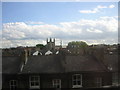
Church in Queenstown Road
I think this may be St Philips' Church but am happy to be corrected.
Image: © Anne Burgess
Taken: 26 Mar 2017
0.06 miles
9
Battersea, stenchpipe
At the junction of Thackeray Road & Tennyson Street; inspection chamber screwed up, fluted base, no maker's name.
Image: © Mike Faherty
Taken: 22 Aug 2009
0.06 miles
10
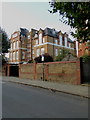
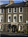
Flats in former school in Thackeray Road
The former Tennyson Street School was latterly the base of the Inner London Education Authority's Educational TV Service. The television centre had two functional television studios, a training studio, a master control and sound and vision mixing suites, together with a mobile section which carried out recordings in schools for use in teacher training. After the abolition of the Greater London Council, the existence of the ILEA ceased in 1988, when responsibility for education was transferred to the London boroughs. The buildings were subsequently converted into a gated housing development.
Image: © Rod Allday
Taken: 7 Oct 2016
0.07 miles