1
Holiday Inn, South Lambeth Rd
Image: © N Chadwick
Taken: 27 Mar 2022
0.03 miles
2
Tia Maria Bar and Kitchen, South Lambeth Road
Clearly a gentrified pub, and 'Wheatsheaf Lane' down the side is a pretty good clue as to what it was called.
Image: © Robin Webster
Taken: 19 Apr 2019
0.03 miles
3
The Wheatsheaf, Vauxhall
Former pub now trading as a Brazilian restaurant called Tia Maria.
Image: © Chris Whippet
Taken: 19 Jul 2015
0.03 miles
4
Victoria Mansions and Victoria House, SW8
An apparently continuous block along South Lambeth Road, the House being at the nearer end. This nearer end must have been rebuilt after wartime bombing - it is mapped as a 'Ruin' on 1949 mapping.
Image: © Robin Webster
Taken: 19 Apr 2019
0.04 miles
5
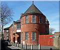
Community hall, Wheatsheaf Lane
Dated 1896 when it was built as a Congregational mission hall. Grade II listed.
Image: © Stephen Richards
Taken: 21 Apr 2013
0.04 miles
6
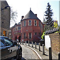
Wheatsheaf Hall Community Centre, Wheatsheaf Lane
A former Congregational mission hall of 1896, grade II listed.
Image: © Robin Webster
Taken: 19 Apr 2019
0.04 miles
7
Victoria Mansions and Victoria House, SW8
An apparently continuous block along South Lambeth Road, the Mansions being at the nearer end.
Image: © Robin Webster
Taken: 19 Apr 2019
0.05 miles
8
Crown & Thistle, Vauxhall
Later became a Portuguese pub named Vasco de Gama then later Nacional de Londres.
Image: © Chris Whippet
Taken: 19 Jul 2015
0.05 miles
9
Shops and Flats on South Lambeth Road.
This is near the junction with Old South Lambeth Road. The flats are Victoria House and Victoria Mansions. Many of the shops and eating places here have a Portuguese connection.
Image: © Danny P Robinson
Taken: 19 Oct 2007
0.05 miles
10
Wyvil Primary School
Image: © N Chadwick
Taken: 27 Mar 2022
0.05 miles


